
This spatial transect was taken at 9:12 UTC. Initially at the first station, the
velocity was lowest closest to the Eastern boundary of the river, reaching speeds
of 0.258 ms-1. The maximum river depth was 7.07 m. This is assumed to be mostly river
water given the tide was ebbing at a reasonable rate of 3 hours before low tide,
with an average speed of 0.195 ms-1. The flow was greater at the Western boundary,
at about 0.428 ms-1. On the site’s temporal transect, a volume transport estimate
of 0.609 m3s-1 was made. The majority of the track lines were pointing to the South
in respect to the river in the transect, and in comparison to the other stations
were larger, given the discharge rate and relative tide time. This meant water was
flowing out of the estuary and into the English channel. Flow between the shallow
and deep areas was similar, because of the small difference in depth. Further speculation
can be made into the reasons behind the differences in flow across the spatial transect.
The changing velocities can be explained by the dynamics of the confluence between
the Tresillian and Truro rivers. It can be seen that the faster Southward flow is
to the Western side of the transect, and given the site’s location could be due to
both the bathymetry of the station, as well as the source of the water upstream.
The bathymetry indicates that the Eastern edge of the transect is more shallow, and
this could be due to deposition of suspended material. That evidence suggests this
is the slower part of the transect, which is supported by the ADCP data, and the
fact that the station being sampled was at a river meander. Therefore the thalweg
of the river is on the Western boundary, which is most likely to support the highest
amount of suspended particles of silt.
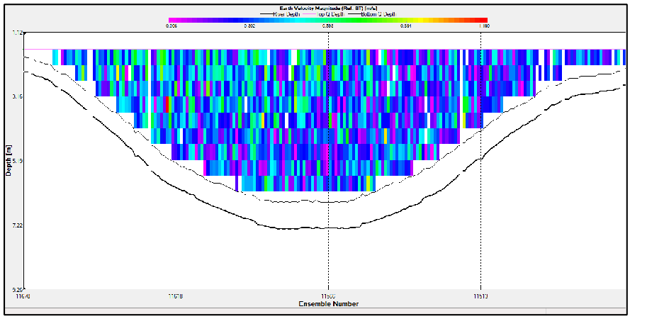
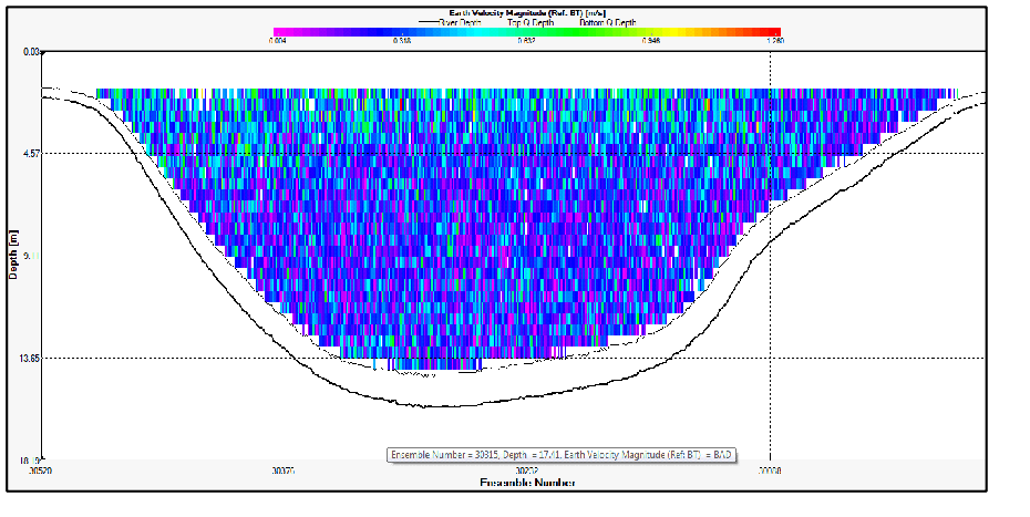
The spatial transect at this station began at 10:30 UTC. In this transect, the maximum
river depth is 13.69 m. The station’s geomorphological setup means that there are
fluvial dynamics from 2 rivers in the transect. This includes the Fal river and a
deeper tributary, the Restronguet creek. The two are almost separated by a central
bank, which is observed in the ADCP transect. As this station is also the beginnings
of the river mouth, there is a greater tidal influence than Station A14. The tide
at this point is approaching 2 hours before low tide (12:50 UTC according to the
tidal gauge data), which means the tide was still ebbing out of the estuary, and
is supported by the Southward facing sticks on the . 11.54 m3s-1 was the recorded
volume transport on the temporal transect. The Eastern half of the ADCP data suggests
a rough flow estimate of 0.383ms-1. In comparison, the flow was about 0.232ms-1 in
the Western half of the transect, which means that there is a greater flow influence
from the River Fal, than from Restronguet creek. Given the deeper channels, there
is some evidence of bottom friction too, and the average flow velocity on the ADCP
temporal transect was 0.247ms-1. There is also some evidence of turbulence within
the water column, given by the contrasting flow velocities within the transect at
intermediate and shallow depth. This could be a contribution by the mixing of both
fluvial channels, and their respective physical properties.
This station’s spatial transect was sampled at 10:58 UTC, close to the King Harry
Reach pontoon location, with a depth maximum of 15.87 m according to the ADCP. The
bathymetry indicates that there is still a significant bank that was seen first in
Station B15/16. This could evidence of sea level rise, or central channel deposition.
Nonetheless, The ship’s track sticks across the transect show a more varied flow,
which could indicated turbulence. Volume transport was recorded as -5.981m3s-1, and
a flow of 0.142ms-1, both obtained in the temporal transect. In comparison to sites
A14 and B15/16, flow was progressively slower, and discharge was falling. This is
again evidence of the increased tidal influence approaching the estuary. Water flow
in both halves of the spatial transect were much similar in velocity, and 0.339ms-1
was the average flow at this site.
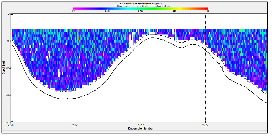
At this station, spatial transect began at 11:29 UTC. The maximum depth at the site
was 16.91 m. There is a small divide between shallow and deeper water across the
transect. Flow in shallow water was roughly 0.529 ms-1, whereas in the deep the water
was seen to be slower at 0.232ms-1. The station average was 0.242 ms-1, with a volume
transport of 61.848 m3s-1, concluding that the increased transport is evidence of
the station’s location, which is past the river mouth and into the estuary. The ship’s
track sticks are still mostly pointing to the South, however in the Western edge
are pointing in a number of directions, supporting the idea of increased turbulence.
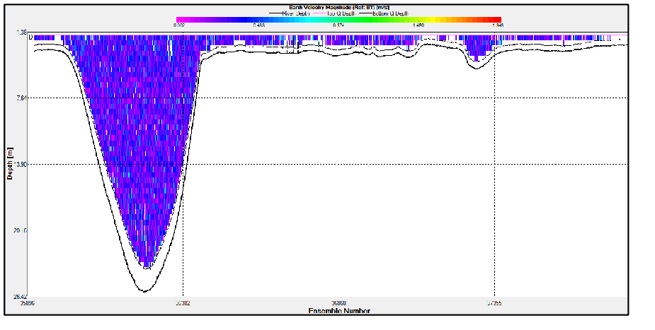
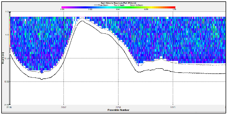
This station was sampled at 12:15 UTC near Turnaware Point, having already approached
slack water at low tide. This is evident in the temporal transect, which recorded
an average flow of 0.059 ms-1, and volume transport of -90.231 m3s-1. The maximum
depth was 25.91 m, though a more specific average across the transect was about 4
m. The ship track sticks are facing in many directions, with some facing North up
the Fal Estuary. This would suggest a turn in the ebb tide, and in sequence, the
beginning of the flood tide in the Fal estuary. The spatial transect was a lot more
convoluted with regards to the bathymetry. This again could be a contribution of
a palaeo channel, which are evident in the Fal Estuary, as deep channels at the time
of the last Holocene glaciation.
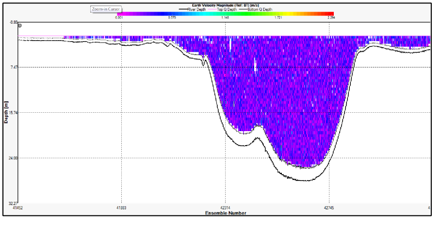
This Station’s spatial transect began 12:56 UTC in the Carrick Roads area. The maximum
depth here was seen to be 28.15 m. The visual flow image is homogenous, which is
similar to that of Station E19. Water was still rather slack, with a temporal flow
of 0.041 ms-1 and volume transport -58.678 m3s-1. This indicates that the net transport
was back into the estuary, just past the turn of the tide. Ship track sticks are
also pointing in many directions, with only a small specific Northward direction
evident.
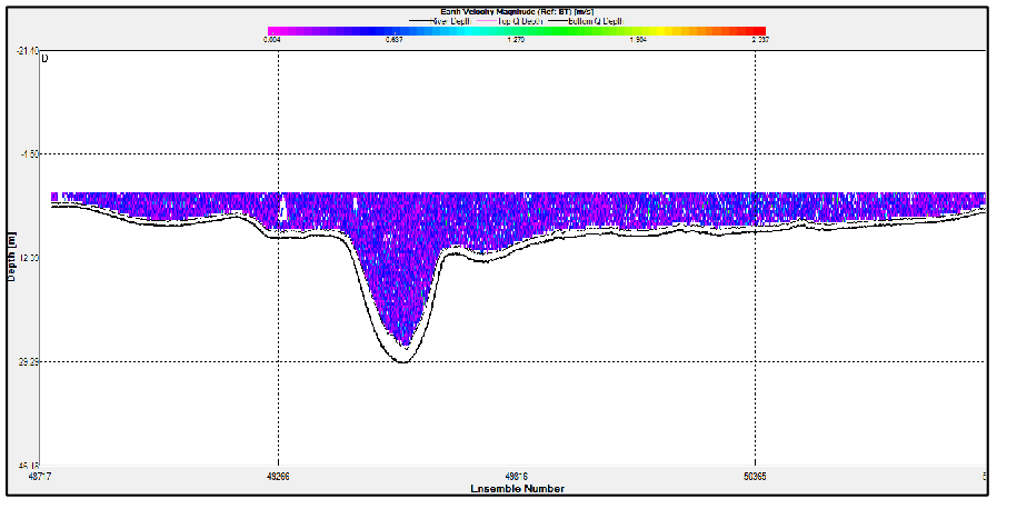
This site in the estuary was Black Rock and the spatial transect began at 13:52 UTC,
with some riverine influence from the mouth of the Percuil River by St Mawes. The
maximum depth was 32.3m at this station. The volume transport was recorded on the
temporal transect as -688.172 m3s-1, and the flow at 0.261 ms-1. This measurement
means that the flow has slowly picked up, given the flood tide. The ship track sticks
across the transect were uniform, and heading North North West, flooding back into
the estuary given the recent passing of low tide 1 hour before.

The views and opinions expressed on this website are those of individuals within
group 8 and are not associated with The National Oceanography Centre, University
of Southampton or Falmouth Marine School.