
GEOPHYSICS
Introduction
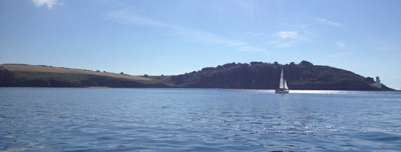
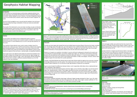
A geophysical survey was conducted in the Fal Estuary on the 27th of June 2015 in Carrick Roads, close to Penarrow point. The surveyed site is of particular scientific interest regarding benthic community structure and biodiversity, due to its designated as a marine Special Area of Conservation. A side scan sonar towfish and a high resolution video camera were used to investigate the bathymetric characteristics of the area and the benthic species present. Key geological features were translated from the sonar paper trace onto a track plot produced from navigation data on Image J, along with video traces. The following poster was created in order to represent the data collected and the conclusions that were drawn.
.
Summary of Findings
Two major habitat types were found in the surveyed area, with Habitat 1 dominating the northerly region of the surveyed area . In contrast, Habitat 2 was more common in the southerly region of the survey area, where it was present in patches surrounded by Habitat 1.
Both video footage of Habitat 1 and oxygen depth profiles in the local area provide evidence that Habitat 1 is a sublittoral muddy-gravel ; this is supported by the findings of (Mcleod et al. 2005). The geomorphology of the area is very flat with no major sediments features visible on the sonar paper trace.. Habitat 2 appeared on the sonar paper trace as a slight increase in backscatter however no shadows of defining geomorphology were observed, implying that Habitat 2 was also very flat in structure. Using data from (Mcleod et al. 2005) it was speculated that Habitat 2 could be eel-grass; however, oxygen saturations at the estuary floor were 6.5% lower than in the upper layers . This suggested that if Habitat 2 was indeed eel-grass it is in low abundance and/or has a low productivity. Nevertheless, without video footage of Habitat 2, no valid conclusions about its composition could be reached.
Speculation of Eutrophication:
Video footage of Habitat 1 shows very few macrofauna and megafauna. However, the reliability of any count or density data taken from video footage was limited by the high algal cover. It could be argued that the presence of high microbial activity in the sediment (evidenced by the sharp reduction in oxygen saturation level at the estuary floor), along with high algal cover and reduced megafaunal communities, either indicate a habitat recovering from disturbance or the beginnings of a stressed environment at Stage II in the Pearson and Rosenberg model (1978). The apparent low sightings of crustaceans, though higher abundance of worms, in the footage is concurrent with a Stage II environment, and is also noted in Marine Biodiversity Patterns by Queiroga H. et al (2006), where similar observations have been inked to heavy metal pollution.
The surveyed area showed evidence of mearl and seagrass beds, both of which are critical nursery grounds for juvenile fish. Consequently, these areas should be conserved and monitored to ensure a healthy estuarine ecosystem. There was also evidence of dead mearl in the surveyed site, therefore this region should remain a designated Special Area of Conservation.
References
Mcleod, C . R., Yeo, M., Brown, A. E., Burn, A.J., Hopkins, J. J., & Way, S. F. (Eds.) (2005). The Habitats Directive: selection of Special Areas of Conservation in the UK. 2nd edn. Joint Nature Conservation Committee, Peterborough (www.jncc.gov.uk/SACselection).
Pearson T.H., Rosenberg R. (1978). Macrobenthic succession in relation to organic enrichment and pollution of the marine environment. Oceanography and Marine Biology Annual Review, 16, 229-311
Queiroga H. et al (2006). Marine Biodiversity Patterns and Processes, Assessment, Threats, Management and Conservation. Netherlands: Springer. 328-330.
Click images to enlarge
Click poster to enlarge
| Chemical |
| Biological |
| Physical |
| Biochemical |
| Physical |