


University of Southampton 2015©

INTRODUCTION TO THE STUDY

In June 2015, we spent twelve days in Falmouth sampling data from numerous sites. We carried out a survey of the Fal Estuary, an offshore time series survey, a pontoon time series, and geophysical habitat mapping. Having analysed this data, we established general trends in terms of the biology, chemistry and physics of the Fal estuary and coastal waters.

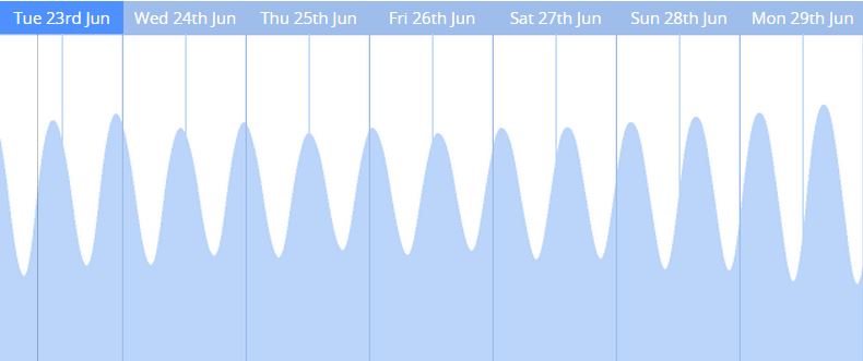
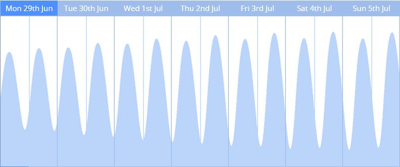
Tides
Data was collected and analysed between Wed 24th Jun and Fri 3rd July; sites were sampled on Wed 24th Jun (Estuary), Sat 27th Jun (Offshore) and Wed 1st Jul (Geophysics).
The tides in Falmouth are semidiurnal and during the trip there was a neap tide on 26/06/2015 and a spring tide on 05/07/2015.

Aims:
- Establish the biological, chemical and physical properties of the Fal Estuary, both spatially and temporally
- Establish the biological, chemical and physical properties temporally, offshore of Falmouth Bay at Standard Station B
- Observe and map the habitat type along the northern end of the Fal Estuary and up into the Truro River
- Create a website to document all of our data findings throughout the field trip
Objectives:
Estuary
Spatial (R.V. Bill Conway)
- Carry out CTD profiles along the Fal Estuary, sampling at maximum depth, the chlorophyll maximum and the surface
- Analyse water samples for nitrate, phosphate, silicate, dissolved oxygen and chlorophyll and create chemical constituent profiles along the Fal Estuary
- Run ADCP transects across the estuary intersecting each station to find river flow
- Tow plankton nets, and identify phytoplankton and zooplankton species
Temporal (King Harry Pontoon)
- Drop equipment at regular intervals collecting data on current, chlorophyll, light intensity and data from a YSI probe
Offshore
Temporal (R.V. Callista)
- Carry out CTD profiles at time intervals, sampling at maximum depth, the chlorophyll maximum and the surface
- Analyse water samples for nitrate, phosphate, silicate, dissolved oxygen and chlorophyll and create chemical constituent profiles throughout the day
- Run an ADCP profile for the sampling time to observe currents
- Tow vertical and horizontal plankton nets, and identify phytoplankton and zooplankton species
Habitat Mapping
- Use a sidescan sonar fish to map the bed of the northern Fal Estuary and the southern Truro River
- Film footage at significant points of interest to confirm the sediment and habitat type
- Have spotters on the back deck of the MTS Xplorer carrying out species identification from the surface
Website
- Upload all data and primary analysis to a website for efficient viewing