


University of Southampton 2015©
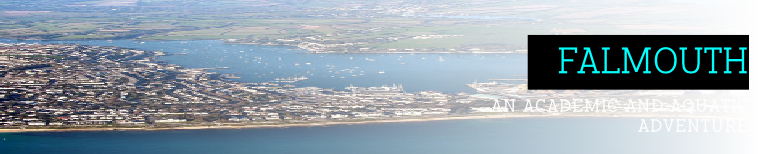


THE FAL ESTUARY
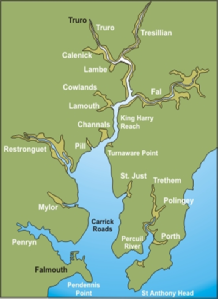
A Special Area of Conservation (SAC) as well as a Site of Specific Scientific Interest (SSSI)[1], The Fal Estuary spans between Pendennis Point at the southernmost end and St Anthony Head at the northernmost end[2] (see Figure 1).
The northernmost tidal limit of the estuary is 18km upstream at Tresilian, and has a total shoreline length of 127km. At Falmouth, the estuary has a maximum tidal range of 5.3m, observable during spring tide, thus is macrotidal at this location. At Truro the Fal estuary has a maximum tidal range of 3.5m, as such it is mesotidal.
There are six main tributaries of the River Fal situated among twenty-eight minor creeks and rivers, including the Truro River, River Kennal, Penryn River and Carnon River, Mylor Creek, Pill Creek, Penpol Creek and Restronguet Creek[3]. The Fal river meanders and deepens southwards, with a depth of 5m in the north at the River Fal, and a depth of 34m in the south at Carrick Roads. Carrick Roads is an outer tidal basin that is no less than a mile wide at any point[3] and makes up ~80% of the estuary’s water body. With a maximum depth of 34 metres and a depth of 10 metres upriver, it is the third largest natural harbour in the world[1]. Carrick Roads is open to the sea, which formed during the last ice age ~10,000 years ago when tectonic movement and riverine forcing, combined with sea level rise, caused the river valley to be drowned.
The Fal estuary is subject to multiple anthropogenic impacts; primarily agricultural runoff from large areas of farmland surrounding the river, the danger of which is the creation of potential eutrophication in the system. It has also been subject to additional sources of pollution and nutrients from local mines, most notably the Wheel Jane tin mine situated in Baldhu, when in 1992 it overflowed following rising groundwater levels, inputting contaminated waters into the Fal Estuary, adversely impacting many species found in the Fal even to this day[1].


Definitions
Estuary - Transitional area between river and ocean/sea; influenced by tides and contains a mix of fresh and salt water.
Macrotidal - A tidal range of >4m.
Mesotidal - A tidal range of 2-4m.
Tidal basin - A basin for boats, accessible and navigable only at high tide.
Eutrophication - Excessive richness of nutrients in water, due to runoff from land, which causes dense growth of aquatic plant life.

References
[1] Pirrie, D., Power ,M., Rollinson, G., Camm ,G., Hughes, S., Butcher ,A. & Hughes, P. (2003) The spatial distribution and source of arsenic, copper, tin and zinc within the surface sediments of the Fal Estuary, Cornwall, UK.,Sedimentology, 50(3), pp. 579-595
[2] Camm, S. And Scott, P. (2003) Location of the Fal estuary [Online] Available: https://projects.exeter.ac.uk/geomincentre/estuary/Main/loc.htm [Accessed: 2015, June 26th]
[3] Cornwall Guide (2015) The River Fal [Online] Available: http://www.cornwalls.co.uk/Falmouth/fal_river.htm [Accessed: 2015, June 26th]