


All the information shown on this website are our own views and not those of the NOCs or the University of Southampton


Estuaries and coastal waters have always been important for shipping, recreation and trade, but on ly recently the importance of these areas to sensitive marine fauna and flora has been realised and the true value of the protection of these areas has become paramount. In the UK several designations exist to protect sensitive ecosystems and species. The Fal Estuary is designated as a special area of conservation (SAC), which ensures a greater amount of protection of the habitats and associated flora and fauna. Estuaries are subject to climatic regulation implications, they provide vital nursery grounds for juvenile fish, and are severely damaged by serious pollution incidents. Therefore the protection of the Fal estuary is key for the maintenance of the vast biodiversity of the estuary, which provides the stability for the changing environment. An additional reason the Fal estuary is considered as a SAC is because of its vast maerl beds which thrive in the drowned river valley due to the reduced wave action. The biological significance of the slow growing calcareous algae in this area was fully understood in 2006, resulting in the ban of the dredging of maerl in the Fal estuary.
To understand the true scale of the benthic biodiversity of the Fal estuary and ascertain whether or not the SAC boundary is arbitrary we collected data using two methods: side scan sonar and video (imaging technique).
Aims
To analyse the seabed and biodiversity outside the Special Area of Conservation at Zone Point in the Fal estuary.
Objectives
Investigate any changes across the boundary of the SAC and the non-protected areas of the mouth of the estuary.
Investigate the variation in formation of the estuary sea bed and its biodiversity.
HABITAT MAPPING
Metadata.
|
Date: |
27/06/2015 |
|
Location: |
Transect 1 - 50⁰08.138N 004⁰59.996W (Start) 50⁰08.137N 004⁰59.993W (End) Transect 2 - 50⁰08.132N 005⁰00.008W (Start) 50⁰08.139N 004⁰59.994W (End) Transect 3 - 50⁰08.140N 004⁰59.996W (Start) 50⁰08.133N 005⁰00.104W (End) Transect 4 - 50⁰08.140N 005⁰00.104W (Start) 50⁰08.141N 004⁰59.996W (End) |
|
Weather: |
Cloud cover 0/8. |
|
Water depth: |
12 -15 m |
|
Time: |
08:15 AST - 09:05 AST |
|
Average wind direction: |
South westerly wind at 9mph. |
|
Tide: |
High water - 14:17 UTC (4.2 m) |
|
Vessel: |
Xplorer |
Introduction.
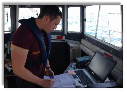
Image 1. Will Grace writing down the northings and eastings for each transect on the vessel explorer.
Methodology.
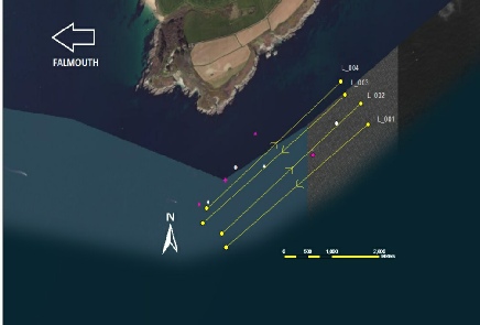
Figure 2. Google Earth map with the transects that were followed during the habitat mapping exercise.
Access to a larger format of the poster.
What we surveyed:
- Backscatter of sea floor using side scan sonar.
- Biodiversity and ground truthing of the sea floor using towed camera
- Visibility was 2 - 3 meters
- Camera footage confirmed the dominant habitat type as Laminaria forest on a rocky substrate. The footage also recorded several fish, both adult and juvenile.
Two techniques were applied to assess the variations across the boundary of the SAC and the non-protected areas; a side scan sonar and imaging technique (video camera). The readings were taken following the previously designed transects. While running the side scan sonar, points of interest were noticed. Afterwards, at this points of interest the imaging technique was used to visualise the habitat in the selected locations.
We were unable to take grab samples due to the rocky substrata. The readings were taken at different times between 08:00 GMT and ending at 11:30 GMT.
CONCLUSION.
In conclusion, the use of sidescan sonar technology provides us with an unparalleled tool into mapping large, previously unreachable areas of seabed. This technology allows us to measure the backscatter from the seabed and using this we can deduce seabed characteristics and then approximate the major habitat types as well as communities present in these areas. The use of ground truthing techniques, mainly live video feeds, provides robust supporting data to confirm the habitats present which can then be extrapolated over the wider survey area. The evidence produced from such techniques is a powerful tool for conservation methods such as Special Area of Conservation (SACs), Marine Conservation Sites or OSPAR sites to preserve areas of biological significance like the Fal Estuary.
REFERENCES.
Bellchambers, L.M., Evans, S.N. And Meeuwig, J.J. (2013). Assessing the Effectiveness of Two Methods of Habitat Characterisation for Understanding Species Habitat Relationships, Using the Western Rock Lobster (Panulirus cygnus). Fisheries Research. 139: 5-10.
Brown, C.J.,Cooper, K.M., Meadows, W.J.,Limpenny, D.S. and Rees, H.L. (2002). Small-scale Mapping of Seabed Assemblages in the Eastern English Channel Using Sidescan Sonar and Remote Sampling Techniques. Estuarine, Coastal and Shelf Science. 54: 263-278.
Kenny, A.J., Cato, I., Desprez, M., Fader, G., Schuttenhelm, R.T.E. And Side, J. (2002). An Overview of Seabed Mapping
Technologies in the Context of Marine Habitat Classification. ICES Journal of Marine Science. 60: 411-418.
Hall-Spencer, J. (1998). Conservation issues relating to maerl beds as habitats for molluscs. Journal of Conchology, Special Publication 2, pp.271-286.
| Biological |
| Chemical |
| Physical |
| YSI Probe |
| Current Meter |
| Chlorophyll |
| Sidescan Sonar |
| Underwater Video |
| Poster |
| Biological |
| Chemical |
| Physical |