
Falmouth Group 8

DISCLAIMER! This website does not necessarily reflect the views expressed by the National Oceanography Centre or any of its staff.


Group 8 Extra transect
Near Low Tide


Group 4 Extra transect
Between Tides


Group 4 station 1
Near High Tide

Black Rock Time Series
Transect 3-
Anomalously high readings were present around the surface layer of the estuary here for the backscatter. Otherwise the backscatter was consistently uniform throughout the water column.
Readings here were taken just after low tide, when mixing is generally at its weakest in the estuary. Therefore there were no differences in the tidal flow throughout the water column, with the tidal flow consistently moving inwards in a northerly direction at approximately 0.5 m/s.
The ship track also displays a variety of directions in which the currents were travelling in.
Transect 2-
This time backscatter was not as uniform as it was previously, with some backscatter over 73 dB occurring on the left side of the diagram.
Tidal flow has also increased with movement now occurring more extensively across the estuary.
A greater volume of water is moving outwards in a southerly direction, and the average flow velocity and direction picked up from the ship track further evidences a general southerly flow along the width of the estuary.
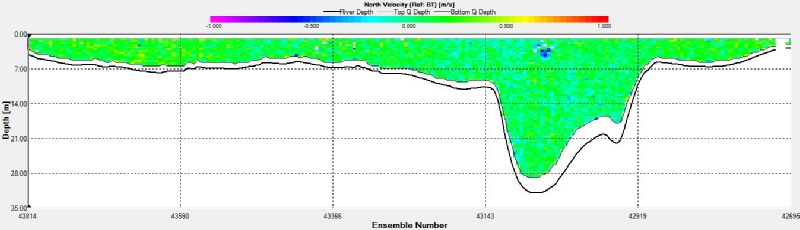
Transect 1-
In terms of backscatter, the ADCP readings are generally consistent apart from the extremities at either end showing high anomalous readings from the turning boat’s wake. On the left side of the diagram tidal flow seemed to exhibit signs of the coriolis force in action as it was being directed southwards to the right at approximately 0.5 m/s.
Evidence of changes in the flow regime can be observed with flow on one side of the
estuary proceeding in a southerly direction down to -
Click graphs to enlarge