DISCLAIMER: These opinions and views are those of the individuals concerned and not those of the University of Southampton.

Aims:
Produce a zoned Habitat Map depicting the different habitats and substrates present by doing a prospect survey along the seafloor of the Falmouth Estuary.
Introduction:
Our primary aim was to produce a prospect survey along the seafloor of the Falmouth Estuary and from our findings produce a zoned Habitat Map depicting the different habitats and substrates present. The Fal’s local populations of mearl and sea grasses which provide important habitats and promote biodiversity in turn improves ecosystem services. Due to the protected status, this location is also a useful indicator of global climate change and provides researchers an area for frequent comparison or control.
Click for Poster
Methodology:
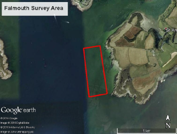
A dual beam side scan sonar system was used to image the seafloor in the targeted area of the Fal Estuary. A low frequency sonar has a low accuracy and a high slant range whereas the high frequency sonar has a high precision but lower slant range. Four transects of 2km long with a 100 m spacing were surveyed. Based on images produced by the sonar system, two locations for grabs and two locations for videos were selected for ground truthing.
The grabs where made using a Van Veen grab but were unsuccessful due to the rocky seabed preventing proper closure of the grab.
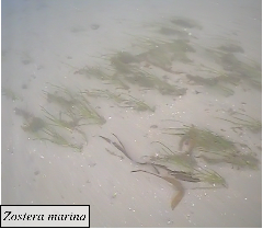
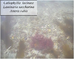
An underwater camera system was deployed while the boat was free drifting due to currents.
A mosaic of the side scan images from the four transects was created to give an overall picture of the surveyed area. By combining observations from the video footage with the side scan mosaic different boundaries were identified to create a habitat map.
GEOPHYSICAL HABITAT MAPPING:
Abstract:
The results of the survey show 2 main seabed substrates (sublittoral sand/gravel and sublittoral coarse sands), with isolated rock outcroppings, as displayed on the habitat map. Ground truthing through Van Veen grabs and seabed video footage confirmed the presence of these major substrates.
Hover over image for description:
| Results and Discussion |
| Results |
| Discussion and Conclusion |
| Results |
| Discussion and Conclusion |
| Results |
| Discussion and Conclusion |
| Methodology Continued .. |