DISCLAIMER: These opinions and views are those of the individuals concerned and not those of the University of Southampton.

The Fal and Helford area includes 60% marine areas with sea inlets, mud flats, sand
flats, lagoons and tidal rivers making up 35%. The wide range of substrata that make
up the local sublittoral sandbanks in this area are some of the most biologically
rich examples found across the UK; in particular of the Zostera marina (seagrass)
which is essential to some fisheries nursery grounds. Additionally , the low tidal
range and sheltered nature of the sandbanks puts the Fal and Helford at a heightened
risk of damage by human activity such as pollution. Also the low freshwater input
from the Fal and Helford has created a wide range of marine habitats with differing
niche conditions including sheltered inlets to wave exposed, tidal areas.
Bird, E, (2000), COASTAL GEOMOROPHOLGY-
Bowen, G, Dussek, C & Hamilton, R. (1998). POLLUTION RESULTING FROM THE ABANDONMENT
AND SUBSEQUENT FLOODING OF THE WHEAL JANE MINE CORNWALL, UK. Geological Society London
Special Publications. 128: 93-
Hunt, L & Howard, A. (1994). ARSENIC SPECIATION AND DISTRIBUTION IN THE CARNON ESTUARY
FOLLOWING THE ACUTE DISCHARGE OF CONTAMINATED WATER FROM A DISUSED MINE. Marine Pollution
Bulletin. 28: 33-
Rijstenbil, J, Merks, A, Peene, J, Poortvliet, T & Wijnholds, J. (1991). PHYTOPLANKTON
COMPOSITION AND SPATIAL DISTRIBUTION OF COPPER AND ZINC IN THE FAL ESTUARY CORNWALL
UK.Hydrobiological Bulletin. 25: 37-
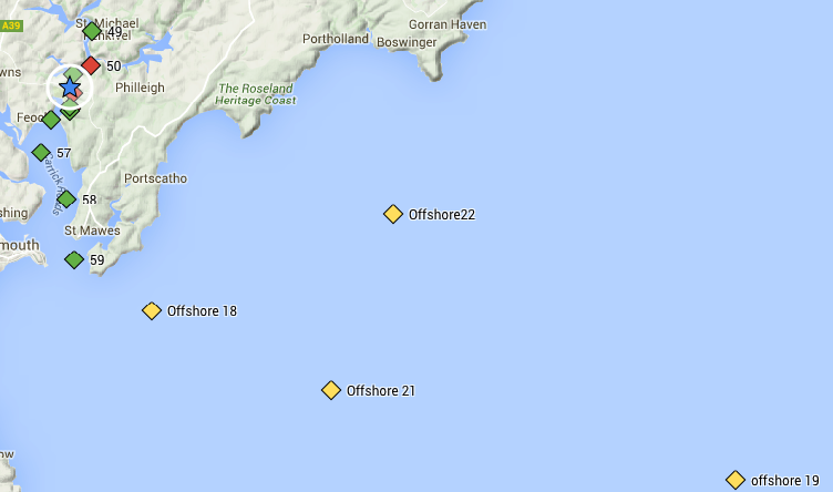
Estuary Stations
Offshore Stations
Below is a map that indicates the station positions of the Estuary survey and the Offshore survey relative to each other.
Falmouth Field Course
2016
Group 4
Falmouth is one of the 652 designated SACs Special Areas of Conservation (SACs), SCIs Sites of Community Importance (SCIs) or Candidates for SAC status (cSACs) in the United Kingdom. The Marine Management Organisation (MMO) is the deciding managing body that oversee the protection of these localities.
The geography of the Fal area has changed over recent history, with the end of the
ice age 18000 years ago that caused the sea levels to rise , forming the modern day
ria estuary -
The Fal estuary became highly polluted with heavy metals, such as arsenic and copper, in February 1991 when Wheal Jane, a tin mine, was closed and the drainage pumps were removed, causing water levels to rise.
In January 1992, the build-
| Results and Discussion |
| Results |
| Discussion and Conclusion |
| Results |
| Discussion and Conclusion |
| Results |
| Discussion and Conclusion |
| Methodology Continued .. |