 back to top
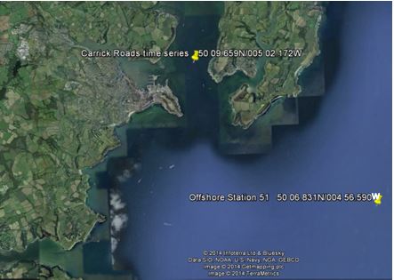
Having collected data from within the estuary, an experiment was conducted offshore. The same set of parameters were measured, thereby enabling us to compare and contrast the estuarine and marine environment. The time series station in Carrick Roads is in the mouth of the estuary and the water column at this position will be subject to a large amount of mixing as the fresher water enters the marine system.
Date: 01/07/2014
Time of offshore measurements: 08:16 UTC
Time of estuarine time series:
09:54 UTC -
Tide:
H/W 07:19 UTC 4.53m
L/W 13:54 UTC 1.09m
Vessel: R.V. Callista
Contributors: All members of group 6, supervised by Alan Kemp.
The original plan was to travel to the Offshore Station and carry out measurements via a transect towards the coast. However, unfavourable weather conditions made data collection unfeasible, such that we returned to the shelter of the estuary for the remaining 8 stations. A time series recording data in hourly intervals was then conducted in Carrick Roads (Fig. 1). This allowed us to observe the diurnal tidal variation and its effects. The methods used to record the data is the same as those described in the Estuary, apart from several alterations. The ADCP transects were not taken at each station, but rather continuously throughout the day. Zooplankton samples were taken in a vertical profile, rather than a horizontal profile taken at the surface.