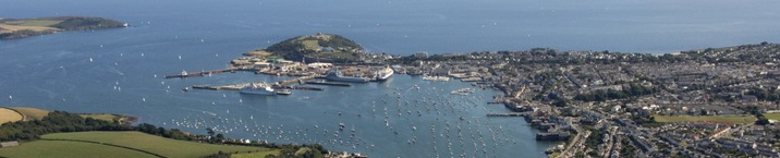
The Fal Estuary situated in Falmouth, West Cornwall, is a ria formed as a result
of rising sea levels during the de-glaciation of the last ice age. The harbour is
reputed to be one of the deepest (34m) naturally occurring ports in the world1 and
has a rich commercial maritime history due to the mining industry and its location
as the most westerly deep-water port in England. The estuary consists of the macro-tidal
M2 dominated Carrick Roads and several meso-tidal tributaries, of which the primary
freshwater sources are the River Fal, the River Helston and the River Truro, however
inputs are generally relatively low as is typical of large estuarine bodies1. The
estuary is orientated north to south and has a mean spring tidal range of 4.6m (chart
datum). Due to the sheltered nature and low sedimentary deposition within the estuary
a broad range of stable benthic biotopes are present.
Throughout history the estuary has suffered a number of detrimental anthropogenic
impacts, associated with metalliferous mining 2. Restronguet Creek, a tributary of
the estuary has purportedly some of the highest heavy-metal contamination observed
in any natural body of water, a problem graphically represented by the Wheal Jane
disaster. Although mining in the area has all but finished residual pollutants remain
within the sediments, with further additions attributable to leaching from spoil
heaps1. Further contamination has been reported within the estuary due to the use
of tributyl tin as an anti-fouling agent for boats, large boats are still repaired
around Pendennis, however much of the modern day maritime traffic in the area is
recreational.
Up until early 2005 maerl (Lithothamnion corallioides) was extracted from the estuary
for use in agriculture as a soil buffer 3, despite relatively little being known
about its significance within the ecosystem. It has emerged that the maerl beds on
St. Mawes Bank are the largest in Britain and in 2009 the area was designated a Special
Area of Conservation (SAC). This has since proved to be contentious with plans afoot
to redevelop the harbour to allow access to the next generation of cruise liners
4.
The area supports various fisheries, predominantly shell-fisheries (>50%) such as
the unique sail-driven native oyster fishery 4. The various three dimensional habitats
provided by maerl and sea-grass beds form a nursing ground for a plethora of species
from cockles (Cardiidae sp.) to seabass (Dicentrarchus labrax. Aquaculture is also
present in the form of mussel farming (Mytilus edulis) and a pacific oyster (Crassostrea
gigas) culture. Although dredging is forbidden within the estuary scallops are still
harvested by divers, and various pot fisheries are also in operation. The stable
mud and sand flats also support commercial bait digging mainly for ragworm (Nereis
diversicolor).
The mouth of the estuary provides sheltered access to the Western English Channel,
leeward of The Lizard relative to the dominant south-westerly winds. This area is
of huge importance due to seasonal stratification of coastal shelf waters forming
tidal fronts with terrestrial outflows. Large scale primary production occurs at
these fronts due to the mixing of the nutrient depleted surface waters and the nutrient
rich outflows5. These dynamic frontal systems form the foundation of the marine
food web throughout the warmer months and provide an excellent indicator of climatic
change due to their shifting locations relative to the North Atlantic Oscillation6.