A geological survey was conducted at Renney Point at Heybrook Bay, to study a rocky outcrop. One particular anti-form fold was studied, with the dip and strike orientation of bedding planes measured, along with the plunge of the fold and a fracture. Secondly, the layers of a cliff were studied visually, also allowing some conclusions to be drawn about the environment at the time of formation.
Whilst other groups used their field geology to inform their initial findings from the habitat mapping, our side scan was a transect of the river, and the field geology was less relevant. Therefore, we have separated our initial findings for the two surveys.
![]()
To investigate the bedding, folding and faults of a fold at Renney point at Heybrook bay
![]()
Date: 04.07.18
Time: 08:15-10:15 UTC
Northing: 048800
Easting: 249200
Conditions: Overcast, humid, cloud cover of 7 octants
Tide: High tide at 10:34 UTC, therefore rising for the duration of the survey
A Suuntoᆴ MC-2D Compass clinometer was used to measure the strike and dip of bedding planes on the outcrop, around the crest of the fold. The direction of the plunge was deduced visually, by finding the flat area at the top of the crest. Its’ angle was measured using the clinometer. A fracture was identified. The hinge was visible either side of the fracture, and therefore the direction of movement of each fragment either side of the fracture could be worked out.
A visual assessment was made of the layers in the cliff.


![]()
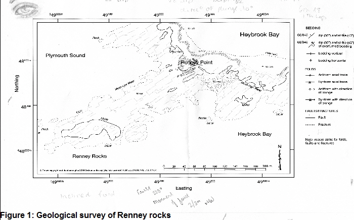
Figure 1: Map showing the area with some orientation of dip and strike and angles of dip labeled. The map shows that the strikes were all in a North Easterly direction, with dips oriented perpendicular to the strikes, towards South East. The plunge direction has also been labeled, at an angle of 10. The symbol indicates it is an anti-form fold. The fracture has been labeled on the map at the landward outcrop and the direction of movement either side, with the axis of the hinge.
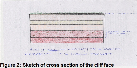
Figure 2: Sketch of a cross section of cliff. It shows 5 distinct layers. The top was soil, the second was beige coloured mud; the third was darker brown/red with clasts suspended in the matrix; the fourth was red, made of coarse sand; and the bottom was made of gravel.
The strikes were all more or less parallel to the hinge axis, as would be expected. However, the direction of the dip was the same either side of the fold. This indicates that overturning has occurred.
The gravel could have been bedload, whilst the clasts may have been delivered glacially, suspended in a muddy flow.

PLYMOUTH FIELD COURSE: THE INITIAL FINDINGS OF GROUP 8