
PLYMOUTH 2018
GEOPHYSICS
GEOPHYSICS
 BACK TO OUR FINDINGS
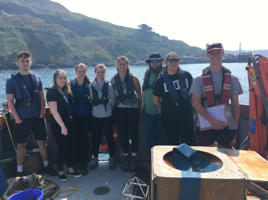
BOAT - XPLORER
05/07/2018
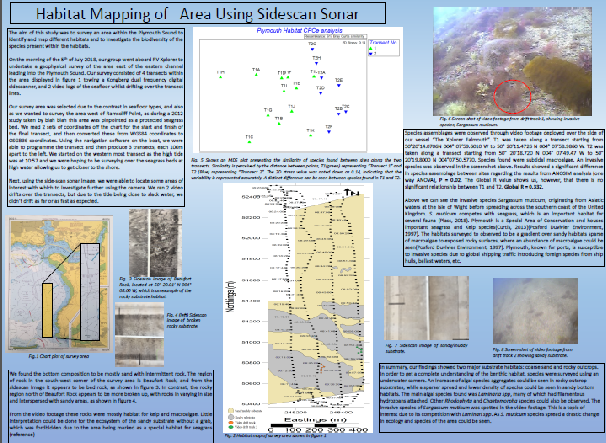
The main aim of the survey carried out on Xplorer was to examine the structure - including mapping the substrate type - of the seabed of the channel east of Plymouth breakwater.
We departed from harbour at 7:15 UTC and returned by 10:30 UTC. High tide was at 9:56 UTC, low tide at 03:35 and 16:50 UTC, conditions were partly cloudy covering 3-4 octants with force 1 winds.
Using a side scan sonar ‘towfish’, the seabed was mapped along four transects along the following coordinates:
Transect 1: 50° 20’08.15’’N to 50° 20’34.90’’N
004°
08’03.90’’W 004° 08’06.54’’W
Transect 2: 50° 21’04.04’’N to
50° 20’06.15’’N
004° 08’34.34’’W 004°07’58.51’’W
Transect
3: 50° 20’06.56’’N to 50° 21’05.93’’N
004° 07’53.72’’W
004° 07’59.11’’W
Transect 4: 50° 21’65.52’’N to 50° 20’08.15’’N
004°
07’59.11’’W 004°07’49.43’’W

Figure 1 - buoy anchor shown on side scan sonar.

Figure 2 - initially laying out our side scan sonar print-outs to identify the substrate types.
In order to survey the benthic habitat in all aspects, in addition to a side scan sonar, a habitat a high-resolution camera mounted to a wing for stability was deployed to the seabed along two drift transects, with start and end coordinates and times as seen below:
Video transect 1: Start time: 09:13
UTC
End
Time: 09:41 UTC
Start Coordinates:
: 50°20’14.0706N 004°
07’59.6010 W
End Coordinates:
50° 20’11.4726 N
004°
07’58.9860 W
Video transect 2: Start time: 09:46 UTC
End
Time: 10:04 UTC
Start Coordinates: 50° 20’18.720’’N
004°
07’49.47 W
End Coordinates: 50° 20’19.8000’’N
004°07’50.5770’’W
Screenshots from this video can also be seen in the poster below.
This benthic video survey showed a well-defined gradient along the first video transect from a sandy bottom, to a rocky outcrop, and ultimately back to a sandy benthic environment. The most common biological assemblages observed were comprised of macroalgae. A trend could clearly be observed along the sand-rock benthic gradient: macroalgae was found more sparsely in areas dominated by coarse sand than in more rocky environments were algal species formed dense aggregates and were highly abundant, covering most of the sea floor. Laminaria spp. constituted the majority of the algal species with Rhodophyta and Chaetomorpha species associated with them. A particularly interesting observation was that of Sargassum muticum in these areas (see Figure 4 on poster below) - an invasive species originating from waters around Japan [1]. S. muticum has been shown to compete with Laminaria spp which is important to the ecosystem as it provides a habitat for several intertidal species [2] [3]. The displacement of Laminaria spp. could therefore have major impacts on the recruitment of species in the area.
In conclusion, the mapped habitats were found to correlate with the data collected from previous benthic survey reports [4] [5] [6]. Algal species densities also corresponded with substrate type as expected - more sandy areas housed more sparsely distributed algae, while rocky outcrops provided an environment of dense algal aggregates.
In order to better understand the results obtained from sidescan sonar geophysics practical, a trip to Heybrook Bay and Renney Rocks was undertaken to investigate the faulting and folding that has occurred over geological time. These rocky outcroppings were initially formed during the Devonian through Carboniferous eras and
FIELD - RENNEY ROCKS
06/07/2018

compliment the shallow marine sediments surveyed at depth during the side scan survey. The presence of cross bedding and ripple markings on the bedding plane suggest deposition of sediments that formed the rocks occurred in an alluvial setting. By observing the displacement of conjugate faults in the rocks and betting planes we were able to observe the direction of max compressional stress over past geological timescales and by measuring the dip and strike of various angled bedding planes, we could begin to get an understanding of how the bedding planes have changed and been warped by geological forces over time and to identify the antiform structure that developed.

Please click on our poster below to enlarge for a more in-depth summary of the findings from the geophysics survey aboard the Xplorer.
REFERENCES
[1] Stæhr, P., Pedersen, M., Thomsen, M., Wernberg, T. and Krause-Jensen, D. (2000).
Invasion of Sargassum muticum in Limfjorden (Denmark) and its possible impact on
the indigenous macroalgal community. Marine Ecology Progress Series, 207, pp.79-88.
[2] Lazzari,
M., Sherman, S. and Kanwit, J. (2003). Nursery use of shallow habitats by epibenthic
fishes in Maine nearshore waters. Estuarine, Coastal and Shelf Science, 56(1), pp.73-84.
[3] Leclerc,
J., Riera, P., Lévêque, L. and Davoult, D. (2016). Contrasting temporal variation
in habitat complexity and species abundance distributions in four kelp forest strata. Hydrobiologia,
777(1), pp.33-54.
[4] Posford Duvivier Environment (1997). Broad scale biological
mapping of Plymouth Sound and Estuaries. English Nature Research Report No. 208.
Peterborough: Engloóidh Nature, pp.1-11, 16.
[5] A Curtis, L. (2013). Plymouth Sound
and Estuaries SAC Seagrass Condition Assessment 2012. Plymouth Sound and Estuaries
SAC Seagrass Condition Assessment 2012. Report Number: ER12-185. Devon: Natural England.
[6] Ware,
S. and Meadows, B. (2012). Monitoring of Plymouth Sound and Estuaries SAC 2011. onitoring
of Plymouth Sound and Estuaries SAC 2011. Final Report (C5521). Suffolk: Cefas.
Or for all references together, see our reference page - here.
| Our Findings Home |
| Offshore |
| Estuary |
| Geophysics |
| C1 |
| C2/3 |
| C4 |
| C5 |
| C6 |
| C7 |
| Falcon Spirit |
| Winnie the Pooh |
| Pontoon |