Introduction
Habitat mapping is a valuable method used to assess and monitor levels of biodiversity
over a range of habitats, using an acoustic survey. The Fal estuary, South-West
Cornwall has been designated as a special area of conservation (SAC) (Langston, 2003)
due to its rich species diversity and habitat variety. It contains habitats such
as eel grass beds, oyster beds and the rare Maerl beds. The area we mapped, along
King Harrys pass towards Malpas contained mostly mixed muddy sediment. These are
often dynamic systems that are essential to a community, as they are often very productive,
nutrient rich areas that contribute highly to the food web (Gerlach, 1978). Due to
such a wide diversification in the Fal Estaury, temporal habitat mapping is essential
in order to monitor environmental changes with the objective of alleviating any perceived
decline.
Methods
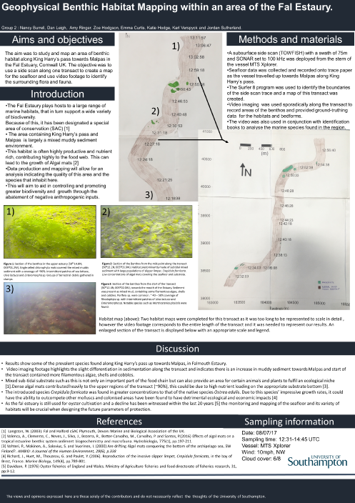
Aim: To study the benthic habitat in a region of the Fal Estaury, Cornwall UK.

A sub surface dual frequency side scan (TOWFISH) was towed 2m behind the MTS Xplorer
at a depth of 1m from the mouth of the Estaury along the King Harry passage up towards
Malpas. Data was collected from the survey and printed onto a paper trace. The swath
was 75m for the device and map projection was OSGB36 and the SONAR was set at 100
khz. After visually analysing the survey, video footage was carried out at 5 locations
on the transact for approximately 4 minutes, at the areas of chosen interest.
The
Video recorder was deployed on the vessels starboard side during the return journey
of the transact and was used to identify species and analyse the bed forms and habitats
of the area. This provided additional ground-truth data to that already collected
by the side scan.
Species of flora & fauna present
Sea lettuce, Ulva lactuca found sporadically in the
upper estuary (50 °14.8 N, 005° 01.2 W) and along King Harry’s pass. Enteromorpha
spp., found in lower concentrations, formed small dense patches along the transact.
In the upper regions of the estuarine system there were extremely high concentrations
of chlorophyte mats covering other benthic fauna (>70% coverage). These algal mats
began to decrease towards the mouth of the Estuary (50° 12.80 N, 005° 07.5 W). There
was also evidence of burrowing activity along the transact but the species responsible
could not be identified using the footage available.
Intermittent Epiphytic rhodophyta
and Porifera spp. recorded along transact, coverage of each increased towards mouth
of estuary.
Marine invertebrate species such as, Mathasterias glacialis and Maja squinado
also occurred in this habitat in small quantities. At (50° 13.5 N, 005° 03.9 W) relatively
high coverage of the slipper limpet, Crepidula formicate found alongside the oyster,
Ostrea edulis. Many shell fish of undetermined species were also recorded during
the ground-truthing data.
Discussion
Our results showcase some of the prevalent species found along King Harry’s pass
up towards Malpas, in Falmouth UK. Video imaging footage highlights the slight differentiation
in sedimentation along the transact and indicates there is an increase in muddy sediment
towards Malpas, whereas the start of the transact contained more filamentous algae,
shells and cobbles. However, this distinction was not visible using the side scan
data, emphasizing the importance of using ground-truthing data. Mixed sub-tidal substrate
such as this is not only an important part of the food chain but can also provide
an area for certain animals and plants to fulfil an ecological niche (Langston, 2003).
Dense chlorophyte mats contributed heavily to the upper regions of the transact (50°14.8
N, 005°07.2 W), covering ~90% of the area, this could be due to high nutrient loading
on the appropriate substrate bottom (Vahteri et al., 2000). The source of which could
be the sewage treatment plant located at Malpas.
The introduced species Crepidula
fornicata was found in greater concentrations to that of the native species Ostrea
edulis at the middle of the transact (50°13.5 N, 005°03.9 W). Due to this species’
impressive growth rates, it could have the ability to outcompete other molluscs and
colonised areas have been found to have detrimental ecological and economic impacts
(Richard et al., 2006). As the fal estuary is still used for oyster cultivation and
a decline has been witnessed within the last 20 years (Davidson, 1976) the monitoring
and mapping of the seafloor and its variety of habitats will be crucial when designing
the future parameters of protection.


