The Fal estuary is the third largest natural harbour in the world and has been economically fundamental to many industries. In recent years there has been a major shift towards tourism as a driver of further development. Conversely, The estuary is also ecologically important and is a Special Area of Conservation. As such, activities in the area are highly restricted and this has resulted in conflicting views between those looking to develop the harbour and those with conservation interests.
The aim of this study is to carry out a prospecting survey at St Mawes Bank, (fig. 2) to provide an indication of the physical and biological parameters of the benthic habitats in this area.
The study area covers an area within the eastern Carrick Roads along St Mawes Bank (fig. 2) and consists of 5 adjacent transects at approximately 100m intervals.
- A tow-
fish mounted side- scan sonar provided bathymetric imaging of the study area. A high resolution print out of this data was interpreted to allow key zones and features to be defined. These were then superimposed onto the track- lines of the boat.
- Drop down video camera towed on a sledge, provided ground-
truthing to the data obtained from the side- scan sonar. This was carried out on a separate transect running diagonally/perpendicular to the side scan transects in order to obtain a more representative of the entire data set.
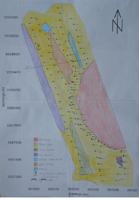
From looking at the side scan we determined different zonations according to contrasting shades and visible features like ripples. Much of the transect appear consistent, which was defined as Maerl beds when this was cross referenced with the video transect.
The rocky headland was a large feature that appears in red on figure 1, and was noted on the boat. Coarse sediment and fine sediment was identified due to different tones in the sidescan which is representative of the backscatter. Benthic macroalgae was identified from delineated sidescan and confirmed by the video. Finally we identified different bedforms through calculating the heights and depths of the features
The majority of video track is through a maerl bed, a mixture of live and dead calcareous algae. Blunden et al. (1981) stated that Lithothamnion corraloides dominates in waters shallower than 6m, with Phymatolithon calcareum dominating deeper than 6m. Due to the water depth within the sampled area (<6m), it is therefore likely that L. corraloides would exclude P. calcareum. The maerl is interlaced with various species of macroalgae the most prominent of which being the rhodophyte, Ceramium rubrum, but other species such as Palmaria fascia, Palmaria palmata and Dilsea carnosa are present but to a lesser extent.
Two species of fan worm were identified the first Serpula vermicularis however this was only identified from the tube. The second fan worm Myxicola infundibulum was identified from its feeding appendages. These fan worms may only be present due to the maerl allowing them to have a holdfast in an otherwise soft sediment environment. The maerl bed also has roaming echinoderm predators such as Marthasterias glacialis (spiny sea star) and Asterias rubens (common sea star) this may be feeding on the barnacles and other bivalve molluscs present in this biotope. However it is impossible to conclude if barnacles were present due the resolution of the video; although shells of several molluscs were seen such as clams, whelks and scallops.
A large Maja squinado (spiny spider crab) which feeds on a great variety of organisms, with seaweeds and molluscs dominating in winter, and echinoderms such as sea urchins and sea cucumbers in summer. Another crustacean found was Liocarcinus depurator (harbor crab) which is most likely a predator/scavenger in this biotope. Also seen was Raja clavata (thornback ray)which predates on small crustaceans such as amphipods and small crabs, it may be a chance that the Raja clavata was spotted <30m away from Liocarcinus depurator but it may also be stalking behavior.
Limitations
As the sampling site is located within an SAC, we were unable to perform
grab sampling for ground truthing purposes. Interpretation of the video transect
is limited to that immediate area, and is therefore not representative of the entire
survey area. This transect did not cover all the different features so not all of
these can be confirmed. Some points were also not covered by the side-
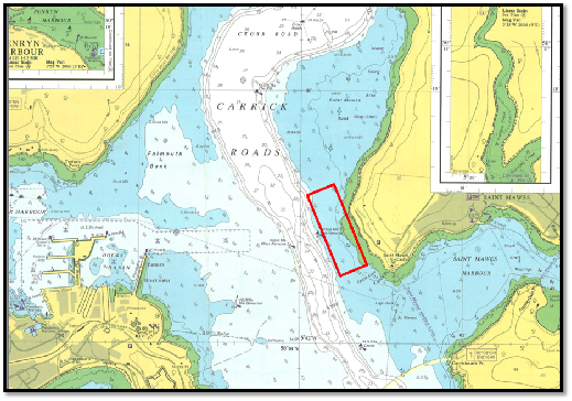
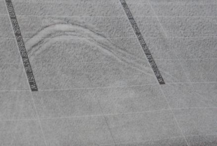
Fig. 3 Anchor scour mark. Click image to enlarge
Fig. 1 Habitat map
Fig. 2 Admiralty chart showing survey site. Site is shown by red box. Click image to enlarge
Interesting features of the sidescan
Several features were observed across the study
area, comprising ripples and signs of anthropogenic impact. Ripples at 50o09.678’N
005o01.921’ W were found to have a mean height of 0.067m whilst at 50o09.776’N 005o01.695’W
the mean height was found to be 0.036m. Mega ripples were observed at 50o09.930’N
005o02.072’W – these had a mean height and depth of 0.1226m and 0.72m respectively.
Another interesting feature observed during the benthic habitat mapping was an anchor
scour mark (fig. 3). This was observed at 50o09.798’N 005o02.0800’W and had a depth
of 1.56m and height of 0.265m.
Click on image to open in PDF
Disclaimer: The opinions and conclusions expressed in this website are not affiliated with those of the National Oceanography Centre or the University of Southampton.
| Introduction |
| Methodology |
| Physical analysis |
| Chemical and phytoplankton |
| Zooplankton |
| Introduction |
| Methodology |
| Side-scan |
| video transect |
| Limitations |
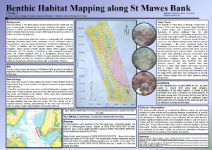
| Poster |
| Introduction |
| Methodology |
| Results |
| Limitations |
| Introduction |
| Methodology |
| Physical analysis |
| Chemical analysis |
| Biological analysis |
| Limitations |