Special areas of conservation (SAC) is a framework to protect listed habitats and species. Rare species are known as “site interest features”. The rare maerl and seagrass reefs were influential in the Fal & Helford region gaining SAC status in 1994, with both bed communities being included in Conservation Objective 3 of the Fal & Helford SAC Management Scheme “to maintain the SUBTIDAL SANDBANKS in ‘favourable condition’, taking account of natural change”.


Eelgrass (Zostera marina) is a species of seagrass that is widespread around the world. As in the Fal Estuary, it is found on subtidal/sublittoral sandbanks in shallow water. Eelgrass provides a habitat for a range of invertebrates, sea slugs, cuttlefish, and fish nurseries.  Any activity that disturbs the sediment in which eelgrass grows, or reduces light levels, puts the species at risk, for example: eutrophication, algal blooms, and man-made structures that shade benthic habitats or reduce the supply of sediments for the base of the habitat.


Sea Lettuce (Ulva lactuca) is one of the most well known shallow water seaweeds, found in both high and low intertidal zones and marshes. Whilst Zostera marina is hindered by nutrient loading, Ulva lactuca has a much higher tolerance to pollution with their growth stimulated by the presence of pollutants; this explains their existence in the Fal Estuary, where there is a high level of anthropogenic activity. In areas with a high concentration of sea lettuce, other vegetation (such as eelgrass) is unable to compete for sunlight, preventing photosynthesis and resulting in the decline of the other vegetation.


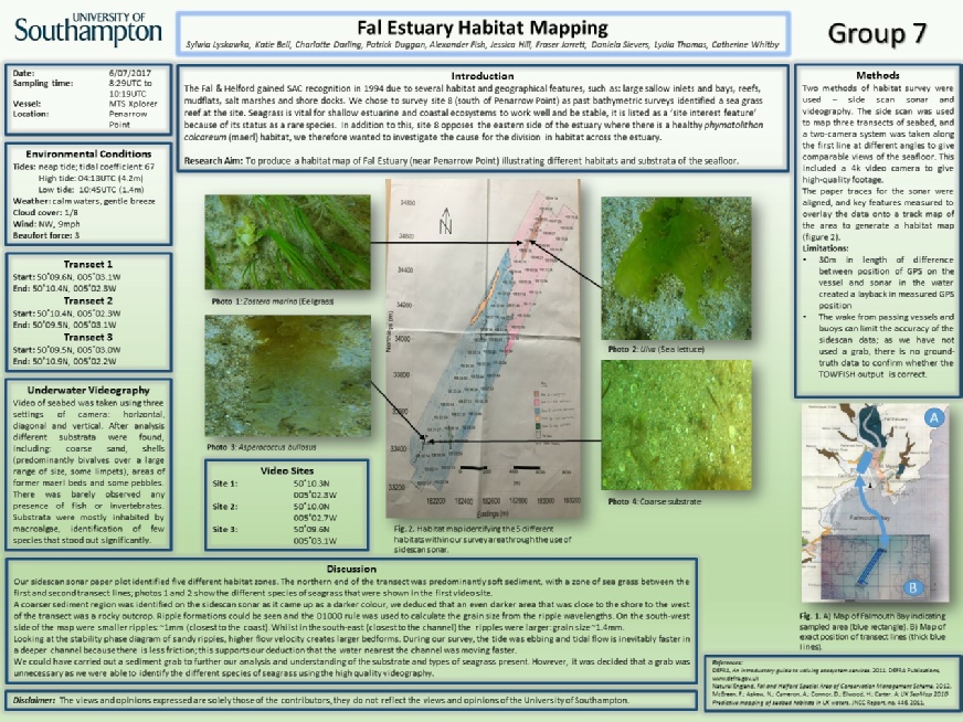
This map of the Fal Estuary (Map 1) has highlighted the locations of interesting features. The north of our survey area was identified as having sublittoral sediment with eelgrass. In the south, the substrate changed to tide-swept sheltered sublittoral rock with kelp. The habitat map we produced shows a similar change in habitat along this area: eelgrass was found in the north of the transect on finer grained sediment, and to the south we saw the sediment become coarser with some rocky outcrops closer to the shore.


Introduction

Poster

Top of Page Slide1.JPG

Map 2: Map of side scan data collection site.

Top of Page Return Home See our References

Map 1: Map displaying the Fal Estuary habitat types.

Video Clips

Top of Page

Explore site 1 by clicking on the pictures above to take you a video of the site!

Explore site 2 by clicking on the pictures above to take you a video of the site!

Transect Line

Start

End

1

50o 09.6N

005o 03.1W

08:29 UTC

50o 10.4N

005o 02.3W

08:44 UTC

2

50o 10.4N

005o 02.3W

08:47 UTC

50o 09.5N

005o 03.1W

09:01 UTC

3

50o 09.5N

005o 03.0W

09:02 UTC

50o 10.9N

005o 02.2W

09:17UTC

Date

06/07/17

High water UTC

03:13

15:37

Low water UTC

09:45

22:08

Time out of dock  UTC

07:15

Time return to dock UTC

11:00

Weather

1/8 cloud cover,

9mph wind, NW direction

Calm water

Disclaimer: The views and opinions expressed are solely those of the contributors, they do not reflect the views and opinions of the University of Southampton.


Table 1. Table displaying the environmental conditions and times (UTC) of data collection within the estuary.


Table 2. Table showing the coordinates and time of sampling (UTC) at each station (1-3) along the transect line of the habitat mapping site.

HABITAT MAPPING

Home Estuary Offshore Pontoon Habitat mapping References

Falmouth 2017 - Group 7