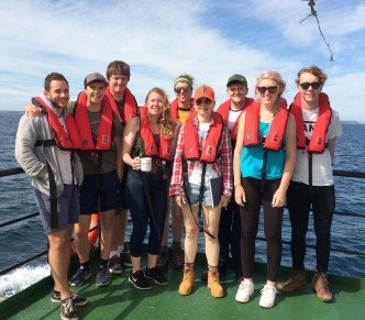
From left to right: Harry Stanton, Toby Miller, Harvey Robinson, Célia Stachowiak, Rachael Taylor, Carole Brennan, Sean Kear, Emily Hoad, Matt Clamp

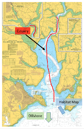
The Fal estuary is a drowned river (‘Ria’) in the western Cornish Fal catchment; extending 29km south from the source at Goss Moor, with freshwater inputs from the Tresillian and Truro rivers, emptying into the third largest natural harbour in the world at Falmouth (West County Rivers Trust, 2009).
At the end of the last glaciation period, significant sea level rise led to the flooding
of the catchment area and formation of a steep depth gradient between the main channel
and extending catchment in the lower stage. Anthropogenic impacts include dredging
activities, oil, sewage outlets and release of anti-
Not only are the catchment areas significant for it’s socioeconomic importance for localised shellfish fisheries and trading shipments, but also for the unique marine and wetland habitats.
recognition as a Special Area of Conservation since 2005 [5], with relation to it’s historic topographic formation.
From the 4th to the 14th of July 2017 spatial and temporal data was collected from
physical and biochemical samples, which were gathered in the mid-

These unique habitats are derived from the following predominant substrate composites:
● Marine areas, Sea inlets (60%)
● Tidal rivers, Estuaries, Mud flats, Sand flats, Lagoons (35%)
● Salt marshes, Salt pastures, Salt steppes (3%)
● Shingle, Sea cliffs, Islets (1%)
These substrates (Joint Nature Conservation Committee, 2017), along with a low freshwater input characterise the site by a wide range of fully marine habitats with subsequent high biodiversity; including iconic wildlife such as the calcareous algae known as Maerl (Joint Nature Conservation Committee, 2015). In recent years, this has given the catchment site recognition as a Special Area of Conservation since 2005 (Langston, W.J. et al., 2017), with relation to it’s historic topographic formation.
From the 4th to the 14th of July 2017 spatial and temporal data was collected from
physical and biochemical samples, which were gathered in the mid-

Disclaimer: The views and opinions expressed are those of the contributors and do not reflect the views and opinions of the University of Southampton
Bryan, G. W. & W. J. Langston, 1992. Bioavailability, accumulation and effects of heavy metals in sediments with special reference to United Kingdom estuaries: a review. Environmental Pollution 76: 89–131.
Joint Nature Conservation Committee, 2017. Fal and Helford[online] [viewed 12 Jul 2017]. Available from: http://jncc.defra.gov.uk/ProtectedSites/SACselection/sac.asp?EUCode=UK0013112
Joint Nature Conservation Committee, 2015. Maerl beds [online] [viewed 12 Jul 2017].
Available from: http://jncc.defra.gov.uk/page-
Langston, W.J. et al., 2017. Characterisation of the European Marine Sites in South
West England: The Fal and Helford Candidate Special Area of Conservation (CSAC)[online]
[viewed 12 Jul 2017]. Available from: https://link.springer.com/article/10.1007/s10750-
West County Rivers Trust, 2009. Fal River Catchment[online] [viewed 12 Jul 2017]. Available from: http://www.cornwallriversproject.org.uk/geography/fal.html

Figure 1. Map showing the Fal estuary and sample locations
-