
Estuarine Ribs - Vertical Profiling of Fal Estuary
| Return to Home Page | Grey Bear - Geophysics | Bill Conway - Estuarine Analysis | Callista - Offshore Analysis |
|
AIMS:
The aim was to produce a profile of the physical and biological structure of the upper Fal estuary for comparison with mid and lower estuary and offshore analysis.
OBJECTIVES:
The objective of the ribs practical was to measure the temperature, salinity, oxygen concentration and take samples for nutrient concentrations (Nitrates, phosphates and silica) in the upper Fal Estuary. For biological interpretation zooplankton trawls were taken and bottle samples for phytoplankton classification were taken.
METHOD:
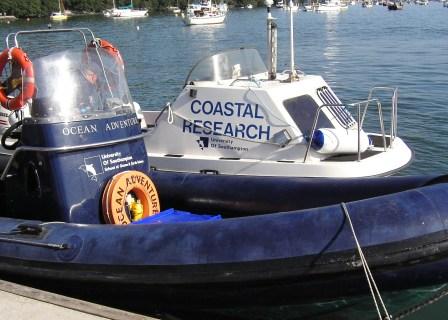
The practical used two inshore vessels to systematically collect data from key points along the upper Fal estuary, namely freshwater inputs and any anthropogenic features that might have affected nutrient concentration. Temperature, salinity and pH were recorded using a YSI probe, oxygen samples were taken from a Niskin bottle and nutrient samples were taken from surface water for analysis in the laboratory. Phytoplankton samples were taken at the same location as the profiling. 1 zooplankton trawl was taken between Church creek and Ruan creek.
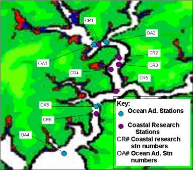
Figure 1 - Map showing station sites for the RIBs boat practical, 16th July 2006
RESULTS:
SALINITY AND TEMPERATURE - The salinity in the area of the estuary studied shows little variation, and suggests low fresh water input. The lowest salinity measured was around 33.5 near Malpas, which is far closer to the town of Truro than it is to the mouth of the estuary. Even when taking into account the low rain fall recently this is a very high salinity for such a location. At most stations the temperature decreases and the salinity increases with depth. This is due to the cold saline sea water having a greater density.
NUTRIENTS - Generally the nutrient concentrations get lower as you travel from the head of the estuary to the mouth, rivers water generally has a higher level of nutrients so this is to be expected.
PHYTOPLANKTON - The ribs were taken out and due to their size could be taken much further up the estuary channel. Going higher up into slightly fresher water and narrow channels with no stratification, diversity was much reduced, and numbers were lower slightly from the main estuary and much lower than towards the mouth. The samples were greatly dominated by diatoms and some dinoflagellates. Refer to Figure 2 below.
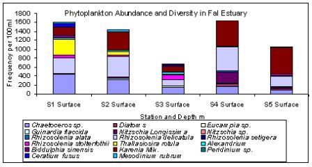
Figure 2 - Bar chart of phytoplankton species diversity from the RIBs boat practical, 16th July 2006
DISCUSSION:
PHYTOPLANKTON - Due to the water not being so readily flushed in the upper channel, there is less mixing meaning some species can easily get a foothold on the community and due to interspecific competition diversity remains low.