
Plymouth Field Trip 2019 - Group 1
On the 6th of July 2019, group 1 went out into Plymouth sound on EchoSound with the
aim to examine and characterise the sea floor to the north east of the breakwater.
This area is of particular interest due to its surprising range of habitats within
the Plymouth sound including fine sediment, rocky outcrops, artificial reef environments
including wrecks and sub-littoral mixed sediment areas which accommodates for some
of Europe’s most threatened species. The particular area surveyed is a special area
of conservation (SAC) but Plymouth sound also hosts special protection areas and
marine conservation zones (Plymouth-MPA, 2014). Habitat mapping is an important component
of today research into conservation and ecology (Hewitt et al 2005). Ultimately,
higher biodiverse systems are better at coping with external stresses such as climate,
and are better at recovering from stresses (Tilman and Downing 1994).


Geophysics - Habitat Mapping

Figure 28: a map of designations in the Plymouth Sound & Tamar Estuaries; © Plymouth
City Council
A side scan SONAR ‘towfish’ was used to map a small section of the sea floor by going
along the four transects. This creates a high-resolution image track plot which is
used to distinguish boundaries which suggest a change in habitat or substrate.
Secondly, deployment of the video recorder was undertaken at two different place
that were identified as areas of interest while on the side scan SONAR transects.
The video recordings were helpful in order to identify species present. A start point
for the recordings was adhered to and the boat was allowed to drift during recording.
To finalise, a ground truthing process took place in which we collected bed sediment
via the Van Veen grab.


Figure 27: an enlarged image with added legend of Figure 3 from the poster below.
|
Date
|
06.07.19
|
|
Start of survey (UTC)
|
08:44
|
|
End of survey (UTC)
|
10:15
|
|
Cloud cover (okta)
|
0
|
|
Seastate
|
Calm-smooth
|
|
High Tide Plymouth (UTC)
|
08:23, 5.27m
|
|
Vessel
|
Echosounder
|
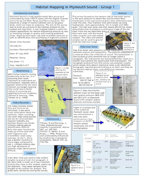
Please click the image below to view an enlarged version of our poster.
Our survey showed a uniform benthic environment, with fine sand with the occasional
rocky outcrop found on both sites surveyed with the ground truthing and grabs. The
video showed the sediment included many apparent polycheate burrows, which were
then confirmed by the grab. Species ID validated that the species found were expected
in the areas. The ID can be seen on the poster below. The sidescan SONAR showed
some distinguishable artifacts on the sea bed, including a shipwreck as seen on
Figure 27.
 Back to top
Figure 29: scientific poster displaying our habitat mapping findings.