
HABITAT MAPPING
GEOLOGY
GEOPHYSICS
Methodology: Readings taken from compasses of the bearings and angle of the rock formations within the bedrock revealed the following information about the geology. Marks were made on a base map of the area, to map the angle and bearing of the strikes in the bedrock.
Within Plymouth, along much of the coast, you can observe dramatic faults and folds in the rocks. These give clear evidence of the immense pressures exerted on the rocks during a period of tectonic plate collision between 330 and 300 million years ago (Visitplymouth.co.uk, 2018). We took a fieldtrip to Heybrook Bay and Renney Rocks to survey the geology.
The survey of the geology located at Heybrook Bay displayed these strikes and dips in the bedrock, characteristic of the area. The survey area contains rock outcrop and intervening unconsolidated sands and gravels. Evident, was a hinge in the bedrock, where on either side the angle of the rocks opposed, creating a mound like fold.
The stratification of the rocks from the base upwards started with a layer of angular and rounded rocks, which have been moved by river flow and above this was a contrasting layer of fine sediment. Then observed was a layer with angular rocks within a matrix, which have come about from a periglacial environment, that would have experienced permafrost melt, resulting in instability, and therefore mass movement occurred such as landslides. Finally located at the top, was a thin layer of top soil.
Moreover, the movement between 2 strike-slip fault lines was observed, one was a sinistral fault, displaying left lateral movement, and one was a dextral fault, with right lateral movement.

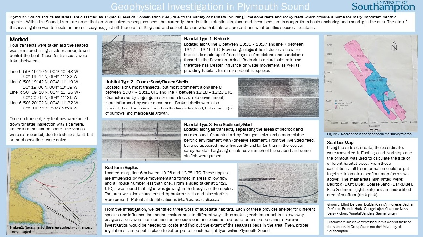
A side scan sonar was used to map out the seabed along the headland in Plymouth Sound. This involved using a towfish down 4 transects, which overlapped slightly to survey a small area. The swath width was approximately 150m with the system running at 100KHz. The side scan sonar works by measuring the amount of sonic backscatter reflected from the seabed, softer sediments such as mud appears lighter in colour where harder substrates such as rock appear darker.
Videography was used to ground truth the area as well as identify species living there. Unfortunately this data was not recorded due to a technical error however notes were taken on what was seen at each site.
METHODOLOGY


courses.nus.edu.sg/course/geosnk/internet/VFT/Airport.html

| Offshore Survey |
| Estuary Survey |
| Habitat Mapping |