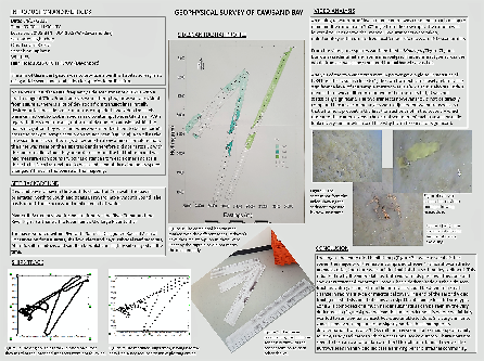
On Wednesday 4th July 2018, our group surveyed a section of Cawsand Bay using MV
Xplorer. 4 Transects were attempted, however because of complications with our captain,
this wasn’t achieved – as shown by the ships track to the left, along with the transects
we attempted to create. Furthermore, timings on the ships track were reset half way
through and the speed of the boat changed twice from 4-
Aims – to investigate the composition of the rock formations at Renney Rocks. This corresponds to the underwater geology of Plymouth Sound, which was surveyed using the side scan survey. Furthermore, the measurements of any apparent folds and faults to plot it on a geological map. Finally, it was necessary to analyse the composition of the cliff to try and work out the geological history of the area.
Methods – measurements were made to quantify the evident folds using a compass clinometer to measure both dip and strike of the rocks. Four measurements were made at different areas of the rock. The slip of the fault was measured by identifying the hinge lines of the fold either side of the fault and measuring the distances between the two.
Results – an antiform fold was identified with 12° of plunge with a displacement of 5m caused by a sinistral fault. The anitform caused bedding to dip away on the east side between 20° and 30°. It also led to overturned bedding on the west side dipping away 34°. This fault had a coupled dextral fault also with 5m of displacement caused by compressional stress.