Disclaimer: All the opinions expressed in this site are that of group 14 and not necessarily the University of Southampton or the National Oceanography Centre, Southampton.

Aim
To conduct a geophysical survey just north of the Fal Estuary in King Harry’s Passage
and produce a benthic habitat map using the transect produced by a Side-
Introduction
The Fal and Helford are Special Areas of Conservation (SAC)[1] , one of the main
reasons why site was surveyed. It was chosen as a SAC for serval reasons including
the large number of inlets and bays providing a range of fully marine habitats. As
well as, the Atlantic salt meadows (Glauco-


Methods
A single-

Figure 2. Van Veen grab
Figure 1. Video Probe
Figure 3. Side Scan sonar towfish
Results and Discussion
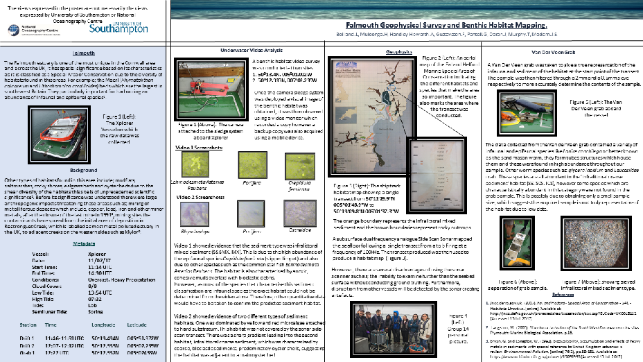
The Side-
Video 1 showed a high abundance of epifaunal species Crepidula femicata (slipper limpet) and common star fish Echinodesmata Asterias Reubens. However, the poor quality of the video made identification of smaller fauna and flora extremely difficult. The video was recorded as the while the boat drifted for five minutes from 50o13.434N, 005o51.372W starting at 11:46UTC.
Video 2 recorded from 50o12.333N 005o02.239W starting at 12:07 and ending at 12:12UTC.
The first habitat, which was not covered by the side-
Using the Marine Habitat Classification for Britain and Ireland3 the site was most closely identified as ‘Infralittoral coarse sediment’ (SS. SCS. ICS) as the sample grab showed a high abundance of infaunal and epifaunal species such as Lanice conchilega (sand mason worm), glycera lapidum and Leucosiidae crab which are characteristic species in this habitat. However, the most abundant species found in this habitat are infaunal species not found in the grab sample. It is possible that the grab sample used was too small to truly identify this habitat and further grab samples would have to be taken to make a definite conclusion regarding this particular habitat.
References
[1] Gov.uk. (2017). Western Channel and Celtic Sea marine area: index map and site
packages -
[2] Jncc.defra.gov.uk. (2017). Fal and Helford -
Click to Download PDF