

Geophysics
For the geophysics aspect of this investigation we chartered a boat out into the Plymouth Sound to study the geology found beneath the waves. Here we used sidescan technology to create a habitat map of the area.
In the aquatic environment direct observation of the seafloor is essentially impossible, even in water as shallow as a few meters, due to the impermeability of the sea. As a result methods that work around the turbidity of natural waters needs to be employed to create maps. Habitat mapping is a useful skill to have as marine biologists and oceanographers as we will most likely go on to use it in our careers because habitat mapping is often used in surveying work.
Method
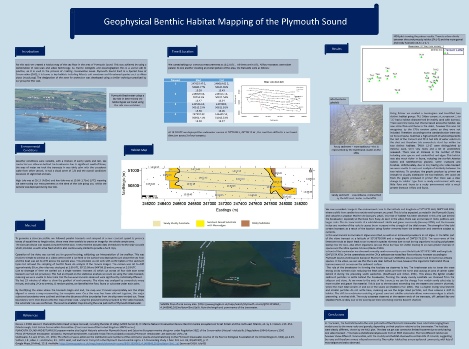
For the method of sidescan, an echosounder is towed behind the boat; a torpedo shaped device that sits just below the water surface. This device gives off an acoustic signal which bounces off the surrounding environment and from this feedback the topology and substrate of the seafloor can be recorded, and be used to generate an accurate map of the sea floor.
A second part of this investigation was to conduct ground truthing; physically looking at the sediment to confirm its composition is what we would expect This is achieved by either a bottom grab or a camera analysis. For our investigation a camera was used as it is less intrusive, this is beneficial as Plymouth sound is a conservation area, and this gave us an opportunity to directly observe the sea floor, a sight rarely seen by us at the surface.
Video 1: This video details the ship track in black, with the red line representing the video transect ship track detailing where the video camera was deployed.
Introduction
Mouse over to see a full size version of the poster