An investigation was undertaken by 2nd year Marine Biologists and Oceanographers from the University of Southampton in the Fal estuary and coastal offshore waters. This was completed from Monday 22nd June to Friday 3rd July 2015, with the field course now running in its 9th year.
The aim of this study is to investigate and compile data including chemical, physical, biological and geophysical parameters, to aid understanding of the processes and interactions occurring in the Fal estuary. Data was collected during estuarine, coastal and offshore boat trips as well as from the King Harry Pontoon. Data was collected from 4 main surveys:
-
-
-
-
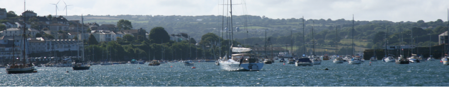
Falmouth Field Course 2015 -
The views and opinions expressed on this page are those of Group 3 and do not represent the views of the University of Southampton, the National Oceanography Centre or Falmouth Marine School.
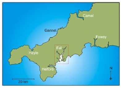
Figure 2.1: Map of Cornwall (Project Exeter, 2015)
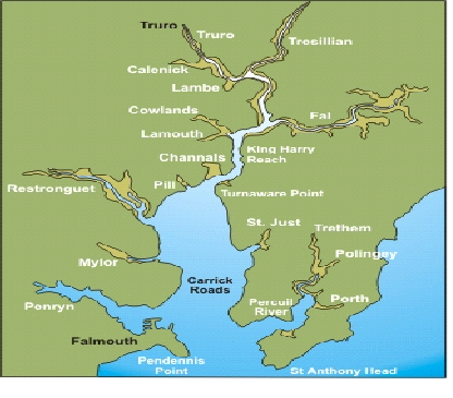
Figure 2.2: Map of Fal estuary (Project Exeter, 2015)
The outer basin is known as Carrick roads and is characterised by deep water channels, with a maximum depth of 34 metres and containing the main water body of approximately 80% of the water volume of the Fal (Hughes, 1999). Within the inner tidal tributaries there are 6 main tributaries and 28 minor creeks and rivers. The tidal range varies with a maximum spring tide in Falmouth of 5.3 metres (macrotidal) (Stapleton and Pethick, 1996) and in Truro of 3.5 metres (mesotidal) (Project Exeter, 2015).
Species that live within the Fal have faced pressures from mining waste and disasters,
such as the Wheal Jane Disaster that contaminated the Fal with the heavy metal tin,
in January 1992 (Younger et al., 2005). Although mining has ended in Cornwall, residual
pollutants still remain within the sediment. Other pollutants have also been deposited
in sediments such as TBTs (Tributyl tin) which was used as an anti-
The estuary is a Special Area of Conservation (SAC) (Figure 2.3) as designated by
the European Marine Sites (EMS) under the habitats directive. SACs are areas supporting
rare, endangered or threatened species (Natural England, 2004). The Fal estuary is
one of the best sites in Europe for marine wildlife due to the presence of two species
of maerl (Rostron 1987), Lithothamnion coralloides and Phymatolithon calcareum found
in an area between St Just and St Mawes. Both these species are a Biodiversity Action
Plan (BAP) species as they are uncommon in England and provide a unique habitat for
a large number of species (Seasearch, 2012). The extent and community composition
of the maerl beds has only recently been described by Seasearch (2012). Maerl is
a calcareous algae which acts as a nursery bed for many commercially important fish
and shellfish. It is incredibly slow-
Although extremely important for biodiversity, maerl is not the only important species
within the Fal. Eelgrass (Zostera marina), a flowering plant, is also a habitat forming
species providing shelter for small organism and also acting as a nursery ground.
Although not protected under Biodiversity Action Plan (BAP), it is covered by the
Habitat Action Plan (HAP) (Tyler-
The Fal estuary is located on the southwest coast of England, West Cornwall. It is
the 3rd largest natural harbour in the world (Cornwall Rivers Project, 2006). The
Fal estuary is a ria (a drowned river valley) (Cornwall wildlife trust, 2015), which
formed in response to the Holocene sea-
Falmouth is an incredibly successful region of Cornwall previously relying economically on its commercial port and fisheries. It also prospered from the nearby heavy metal mining industry, which dates back to the early Bronze Age approximately 4000 years ago (Pirrie et al., 1995). However in recent years there has been a switch from these major industries to tourism,which has rapidly become a leading force for development in the area. Fisheries have continued in the Fal with important species such as the native oyster (Ostrea edulis), seabass (Dicentrarchus labrax), cockles (Cardiidae sp.) and scallops (Pectinidae) being harvested, as well as aquaculture farming for the pacific oyster (Crassostrea gigas) and common mussel (Mytilus edulis). These industries continue the economic importance of fisheries in the Fal (Port of Falmouth development initiative, 2009), despite the introduction of tourism.
The Fal is a large estuary at approximately 18km in length, starting in Truro and ending in between Pendennis point and St Anthony Head in Falmouth, where it enters the English Channel (Cornwall guide, 2015).It is usually subdivided into two areas, the inner tidal tributaries and the outer basin.
Birkett, D. Maggs, C. and Dring, M. (1998). An overview of dynamics and sensitivity
characteristics for conservation management of marine SACs. Report. Available online:
http://www.researchgate.net/profile/Matthew_Dring/publication/242736827_An_overview_of_dynamics_and_sensitivity_characteristics_f or_conservation_management_of_marine_SACs/links/02e7e52ba083f13d1e000000.pdf.
Pp: 56-
Bryan, G. Gibbs, P, Hummerstone, L. and Burt, G. (1987). Copper, zinc and organotin
as long-
Cornwall guide, (2015). The River Fal. Webpage. Available online: http://www.cornwalls.co.uk/Falmouth/fal_river/htm. Date accessed: 27/06/2015
Cornwall Rivers Project, (2006). Geography, Fal and Tresillian. Webpage. Available online: http://www.cornwallriversproject.org.uk/geography/fal.htm. Date accessed: 23/06/2015
Cornwall wildlife trust, (2015). Fal-
Hughes, S. (1999). The geochemical and mineralogical record of the impact of historical
mining within estuarine sediments from the upper reaches of Fal Estuary, Cornwall,
UK. Fluvial sedimentology. Published by The International Association of Sedimentologists.
Vol. 28. Pp: 161-
Iguchi, T. Katsu, Y. Horiguchi, T. Watanabe, H. Blumberg, B. and Ohta, Y. (2007). Endocrine distrupting organotin compounds are potent inducers of imposex in gastropods and adipogenesis in vertebrates. Molecular and cellular toxicology. Vol. 3 Pp: 1.
Natural England, (2004). Fal and Helford SAC Management Scheme. Report. Pp: 1-
Nesbet, E. (1990). The end of the ice age. Journal: Canadian Journal of Earth Sciences. Vol. 32(10). Pp: 1. Date accessed: 27/06/2015)
Pirrie, D. Camm, G. Sear, L. Hughes, S. (1995). Mineralogical and geochemical signature of mine waste contamination, Tresillian river, Fal estuary, Cornwall, UK. Environmental geology. Vol. 29. Pp: 1.
Pirrie, D. Power, M. Rollinson, G. Camm, S. Hughes, S. Butcher, A. and Hughes, P. (2003). The spatial distribution and source of arsenic, copper, tin and zinc within the surface sediments of the Fal Estuary, Cornwall, UK. Sedimentology. Vol.50. Pp: 580.
Projects Exeter, (2015). Location of the Fal estuary. Webpage. Available online: https://projects.exeter.ac.uk/geomincentre/estuary/Main/loc.htm. Date accessed: 24/06/2015
Rostron, D. (1987). Surveys of harbours, rias and estuaries in Southern Britain: Falmouth. Report published by Pembroke: Oil Pollution Research Unit. FSC Report, No. FSC/OPRU/17/87.
Royal Haskoning, (2009). Commercial fisheries and shellfisheries. Report: Port of
Falmouth development initiative. Pp: 249-
Seasearch, (2012). Maerl in Cornwall, 2012 survey report. Report. Available online:
http://www.seasearch.org.uk/downloads/Cornwall%20maerl%202012%20web.pdf. Pp: 1-
Stapleton, C. and Pethick, J. (1996). The Fal estuary: Coastal Processes and Conservation. Report: Institute of Estuarine and Coastal Studies. University of Hull, English nature, Peterborough, UK.
Tyler-
Younger, P. Coulton, R. and Froggatt, E. (2005). The contribution of science to risk-
The analysed data, observations and preliminary findings are all collated onto this website to display details on each of the survey sites as well as including information on biological and chemical laboratory analysis of collected samples. The combined data and investigation from each of the sites together will allow The Fal to be seen as one entity.
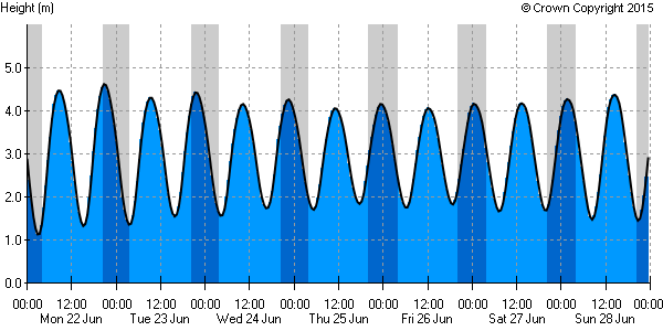
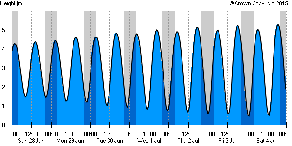
Figure 1.1 & 1.2: Tide charts for Falmouth from 22nd June to the 4th July 2015.
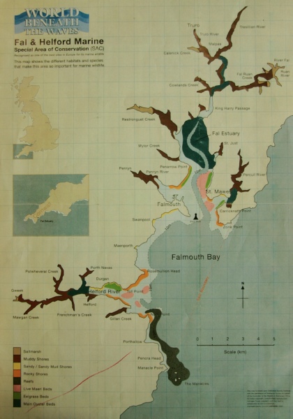
Figure 2.3: map to show SAC areas and areas of interest in the Fal.