Southampton University Falmouth 2015
Group 13
© B Carter
The Fal Estuary is an important environment both economically and ecologically. It is designated as a Special Area of Conservation (SAC), meaning that the biota in the estuary are protected under European legislation to limit impacts from human activities. The Fal Estuary was awarded this protection due to rich sublittoral sand invertebrate communities, extensive regions of seagrass and maerl bed habitats. The seagrass beds offer an excellent nursery ground for fish and other organisms (Joint Nature Conservation committee, 2014)
The Fal estuary hosts a variety of both commercial and recreational activities (Falmouth Harbour Office, 2010). These range from tourist boat trips, through mussel and oyster farming to a major bonded bulk oil terminal that can hold approximately 60,000 tonnes of oil (MBA, 2003).
Historically, the catchment for the Fal Estuary was an area of extensive mining activity, predominantly tin and china clay. Although the last tin mine closed in 1998, the impacts of this pollution are still visible today (PlymSEA, 2006).
The Fal estuary is a ria (flooded river valley), formed at the end of the last ice age due to the subsequent sea level rise. The estuary is very sheltered as it is protected from prevailing south-westerly winds by the Lizard Peninsula to the west. A deep channel, known as Carrick Roads, runs through the estuary and can reach depths of 30m. The fal estuary falls between the southern (Lusitanian) and northern (boreal) biogeographical regions and has elements from each which increase its biodiversity.
Aims
The aims for this study are:
1. To carry out a detailed study of the Fal estuary and surrounding areas to gain a greater understanding of the physical, chemical and biological process that function in this area.
2. To develop field study skills in the subject area of oceanography. To do this a sidescan survey of the coastal area on the MTS Xplorer was completed. A time series on current speed and direction, irradiance, temperature, salinity, pH, density, dissolved oxygen on King Harry's ferry pontoon was also completed. The physical, chemical and biological characteristics will be analysed along the whole stretch of the Fal estuary with group 1 on the R.V. Bill Conway.
3. To use the ADCP to analyse the backscatter and flow of the water column. To use the CDT to analyse the temperature and salinity depth profiles at each station. To take samples using the niskin bottles to take nutrient and chlorophyll samples to analyse the levels at each boat station. Taking phytoplankton and zooplankton samples to look at the community structure at each station.
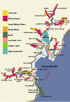
Figure 1 - Map of Falmouth Estuary
Introduction
Special Area of Conservation
There are four habitats found in the Fal estuary which act as a primary reason for the classification of the Fal as an SAC. The first is 'Sandbanks which are slightly covered by sea water all the time'. Falmouth has some of the best examples of sandbanks in the UK with especially rich sublittoral sand invertebrate communities with eelgrass (Zostera marina) beds near the mouth of the Fal. The Fal also has some of the most extensive maërl beds in the Britain that lay host a wide range of epifaunal and infaunal species, including some rare species, such as Couch’s goby (Gobius couchi).
The second habitat is 'Mudflats and sandflats not covered by seawater at low tide'. The mudflats and sandflats found in the Fal are particularly recognised for the importance of the species living in the sediments, including amphipods, polychaete worms, the sea cucumber Leptopentacta elongata and bivalve molluscs. As the Fal is such a sheltered site, the sediments are both stable and diverse and support nationally important sediment communities.
The third habitat is 'Large shallow inlets and bays'. The ria (drowned river valley) of the Fal has a low freshwater input causing there to be many different fully marine habitats, ranging from extremely sheltered in the inlets to the wave-exposed, tide-swept open coast. There is a particularly diverse algal flora and a number of warm-water species are present.
The fourth habitat is 'Atlantic salt meadows (Glauco-Puccinellietalia maritimae)'. The Fal is an example of saltmarsh vegetation in a ria, a physiographic type restricted to south-west England and west Wales. There is a narrow saltmarsh zonation typical of rias, from pioneer to upper marsh, and transitions to woodland where the fringing trees overhang the tidal river, an unusual juxtaposition of vegetation in the UK.
References:
JOINT NATURE CONSERVATION COMMITTEE, (2014), Fal and helford – Special Area of Conservation – SAC – Habitats Directive, [accessed 02/07/2015], http://jncc.defra.gov.uk/protectedsites/sacselection/sac.asp?EUCode=UK0013112
FALMOUTH HARBOUR OFFICE, (2010), Environmental Code of Practice – The Fal Estuary, [accessed 02/07/2015], http://www.falmouthport.co.uk/commercial/html/documents/environmentalcop2010.pdf
MARINE BIOLOGICAL ASSOCIATION, (2003), Site Characterisation of the South West European Marine Sites – Fal and Helford cSAC, [accessed 02/07/2015], http://www.mba.ac.uk/nmbl/publications/charpub/pdf/Fal_Helford.pdf
PLYMOUTH MARINE SCIENCE ELECTRONIC ARCHIVE (PlyMSEA), (2006), Heavy metals in the Fal estuary, Cornwall: A study of long term contamination by mining waste and its effects on estuarine organisms, [accessed 02/07/2015], http://plymsea.ac.uk/275/
Grasshoff K., Kremling K., Ehrhardt M., (1999), Methods of seawater analysis. 3rd ed, Wiley-VCH
Jncc.defra.gov.uk,. Fal and Helford - Special Area of Conservation - SAC - Habitats Directive. (2015). at <http://jncc.defra.gov.uk/protectedsites/sacselection/sac.asp?EUCode=UK0013112>
Disclaimer: The views and opinions expressed are those of the individual and not necessarily those of the University of Southampton or the National Oceanography Centre, Southampton.
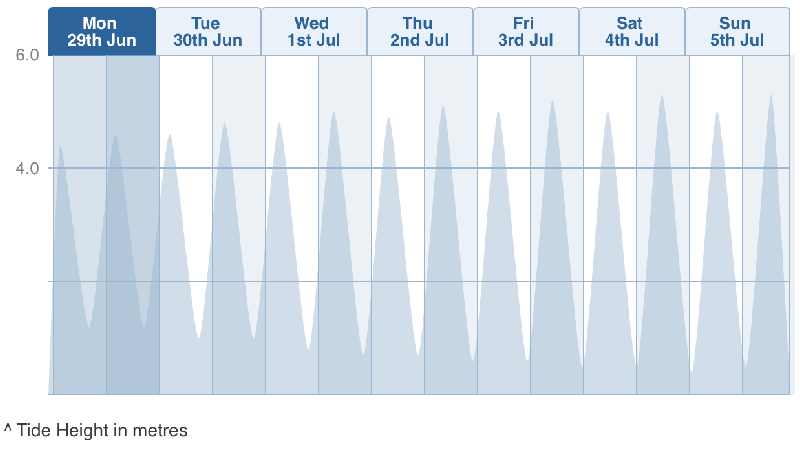
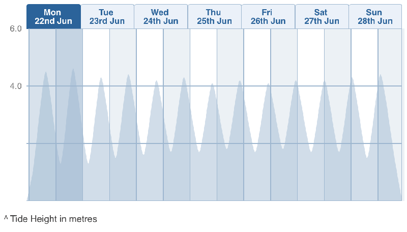
Figure 2: Tide Charts for 22.06 - 28.06
Figure 3: Tide charts for29.06 - 05.07
Tidal charts for 22/06/2015 - 28/06/2015 showing high and low tide cycles with height of tidal wave in meters.
Tidal charts for 29/06/2015 - 5/07/2015 showing high and low tide cycles with height of tidal wave in meters.