

Introduction
We have conducted an investigation of the Fal estuary, South-
The Fal
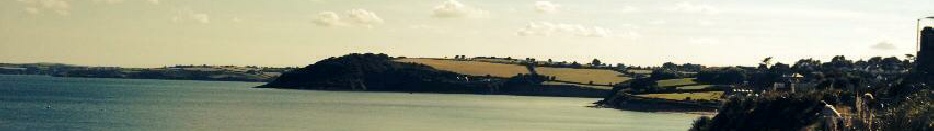
Falmouth estuary is a unique environment, designated a special area of conservation (SAC) and site of specific scientific interest (SSSI) due to its diversity of estuarine organisms and habitats, as well as rare or endangered species. As the world’s third deepest natural estuary (34 metres; 10 metres upriver) [1], it has served as a busy port dating back to the 1100’s, and so naturally there has been a great deal of human impact on the surrounding habitats [2].
The estuary itself is a drowned river, valley or ria, and dates back ~10,000 years; it was formed during the last ice age, as a result of tectonic movements and riverine forcing, and a subsequent sea level rise. The majority of the estuarine system is contained within the Carrick Roads area, which starts at Black Rock and extends four miles to Turnaware Point and the transition from the river to estuarine system, and is at least one mile wide throughout.
There are six main tributaries to the Carrick Roads, the predominant sources being the River Fal, the Truro River, and the River Carnon, as well as twenty eight creeks and smaller rivers. Despite this, heavy sedimentation, human impact and the estuary bed morphology has limited the fresh water input upriver, resulting in a tidal dominated estuarine system. In addition, the estuary’s [greater than average] depths create salinity gradients unique to deeper channels where tidal water input is much greater than that of fresh water, and so higher levels of salinity can be observed much further upriver than in most estuarine systems.
Salt marshes are subsequently found further upriver, which offer further habitats for the local and migrating species and one of the main reasons behind the SAC designation. Furthermore, the Fal Estuary contains rare species of Maerl; Phymatolithon calcareum, and Lithothamnion coralliode, as well as [Zostera sp.] seagrass beds [3]. These habitats are of great scientific importance and covered under SAC and SSSI regulations. In recent years, the Falmouth Harbour Commissioners have been under a great deal of pressure to expand the local Ports, which would require dredging the estuary channels several metres in particular areas; debates on consequential effects of this the rare species in the area are still ongoing.
[1] Pirrie, D., Power, M., Rollinson, G., Camm, G., Hughes, S., Butcher, A. and Hughes,
P. (2003). The spatial distribution and source of arsenic, copper, tin and zinc within
the surface sediments of the Fal Estuary, Cornwall, UK. Sedimentology, 50(3), pp.579-
[2] Deeble, M. and Stone, V. (1985). A port that could threaten marine life in England's
Fal Estuary. Oryx, 19(02), pp.74-
[3] Hall-
[4] Widdicombe, C., Eloire, D., Harbour, D., Harris, R. and Somerfield, P. (2010).
Long-
[5] Pirrie, D., Camm, G., Sear, L. and Hughes, S. (1997). Mineralogical and geochemical
signature of mine waste contamination, Tresillian River, Fal Estuary, Cornwall, UK.
Environmental Geology, 29(1-
[6] Gibbs, P. (2009). Long-
[7] Rijstenbil, J., Merks, A., Peene, J., Poortvliet, T. and Wijnholds, J. (1991).
Phytoplankton composition and spatial distribution of copper and zinc in the Fal
Estuary (Cornwall, UK). Hydrobiological Bulletin, 25(1), pp.37-


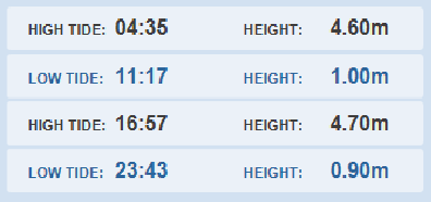
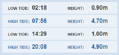
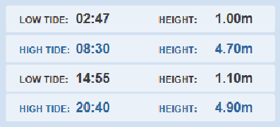
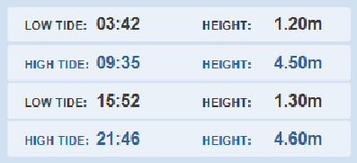
The estuary is macrotidal in the Carrick Roads with tidal ranges of 5.4 metres (tide-
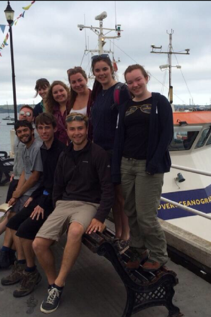

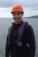
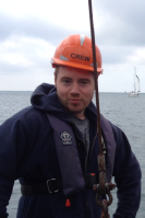


Meet Falmouth 2014 Group 8!
Click on the individual photos below for names, course and contact details.
or the National Oceanography Centre, Southampton.