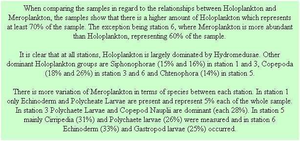
 where p2=highest density and p1=lowest
density.
where p2=highest density and p1=lowest
density.
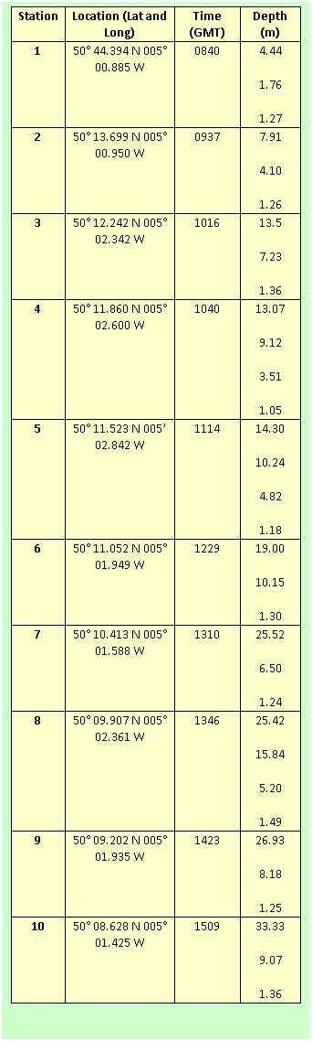
As the CTD didn’t directly record density data, density must be calculated from temperature and salinity data. Because of the impracticality of performing this calculation upon all temperature and salinity records, density has been calculated at highest and lowest temperature and salinity values. From these four values the highest and lowest density was then used in the above calculation. Often the lowest temperature and highest salinity coincided (and vice versa), demonstrating the legitimacy of this ‘back of envelope’ approach.
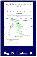
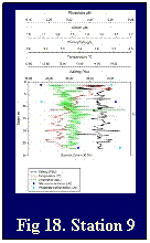
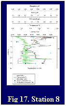
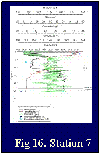
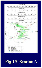
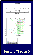
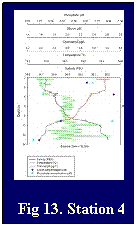
The phosphate concentrations show an inverse relationship with salinity throughout the tidal cycle (fig. 22). The depth profiles show that phosphate concentrations tend to be higher towards the head of estuary, concentrations up to ≈0.9μmol/l, whilst those towards the mouth concentrations tend to be lower, up to ≈0.5μmol/l. The estuarine mixing diagram displays that phosphate is added to the estuary, most significantly at 25psu with a concentration over 3.0 μmol/l.
The silicon concentrations also show an inverse relationship with salinity over the tidal cycle (fig. 23). The profiles with depth also show that higher concentrations of salinity are reached further up the estuary, up to ≈7.0 μmol/l, whereas the maximum for the bottom half of the estuary is ≈4.4μmol/l. The estuarine mixing diagram shows silicon behaves conservatively up to a psu≈15, after this salinity silicon is removed from the estuary.
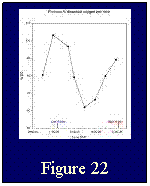
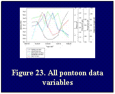
The dissolved oxygen sampled in the surface waters at the pontoon (fig. 22) showed the ebb tide to bring oxygenated water, causing a dissolved O2 peak of 103.1% at 11.00GMT indicating super saturation. The flood tide appears to bring two water masses past the station, initially a water mass significantly lower in O2, a minimum 61.9% reached at 14.00GMT. This is followed by a water mass with higher O2 saturation recovering to 89.0% by 17.00GMT.
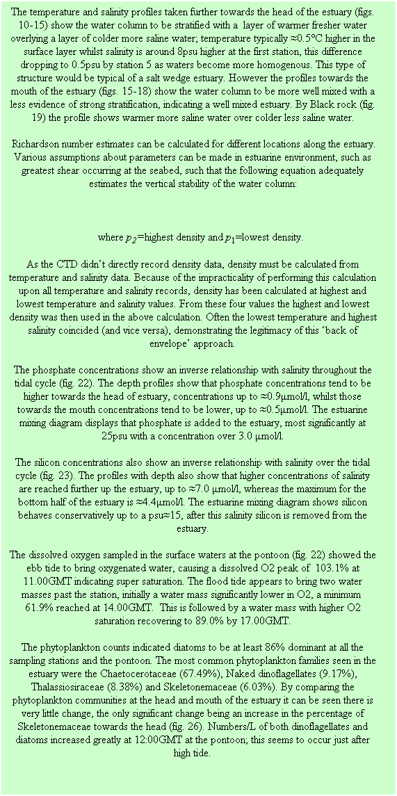
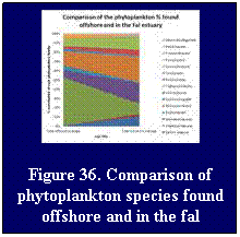
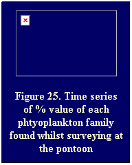
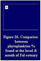
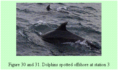
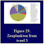
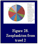
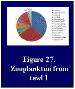
The phytoplankton counts indicated diatoms to be at least 86% dominant at all the sampling stations and the pontoon. The most common phytoplankton families seen in the estuary were the Chaetocerotaceae (67.49%), Naked dinoflagellates (9.17%), Thalassiosiraceae (8.38%) and Skeletonemaceae (6.03%). By comparing the phytoplankton communities at the head and mouth of the estuary it can be seen there is very little change, the only significant change being an increase in the percentage of Skeletonemaceae towards the head (fig. 26). Numbers/L of both dinoflagellates and diatoms increased greatly at 12:00GMT at the pontoon; this seems to occur just after high tide.
|
|


![Text Box: REFERENCES
Bosence D. & Wilsion J., 2003. Maerl growth, carbonate production rates and accumulation rates in the northeast Atlantic. AquaticConserv: Mar. Freshw. Ecosyst. 13: S21 – S31.
Google Earth Screen Shot, 2011, Infotera Ltd &Bluesky Image copywrite 2011 Getmapping PLC.
Irvine L. & Chamberlain Y., 1994. Seaweeds of the British Isles – Volume 1 Rhodophyta Part 2B Corallinales, Hildenbrandiales. London: HMSO.
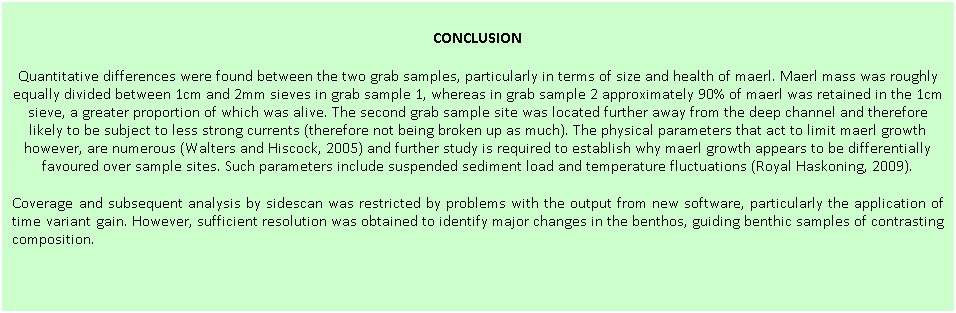
Royal Haskoning (2009). Port of Falmouth Developing Initiative Environmental Statement, Section 8 – Marine Coastal Ecology. From: http://www.falmouthport.co.uk/commercial/html/PortofFalmouthDevelopmentInitiative.php
Langston,W. Chesman,B. Burt,G. Hawkins,S. Redman,J. Worsfold,P. 2003. The Fal and Halford (candidate) Special Area Conservation. Marine Biological Association Occasional Publication. Vol 8 pp91-94
Pirrie,D. Power,M. Rollison,G. Camm,S. Hughes,S. Butcher,A. Hughes,P. 2003. The spatial distribution and source of arsenic, copper, tin and zinc within the surface sediments of the Fal estuary, Cornwall, U.K. Sedimentology. Vol 50 issue 3 pp 579-595
Vaulot, D., 2006. Phytoplankton. eLS.
Langston, W.J., Chesman, B.S., Burt, G.R., Hawkins, S.J., Readman, J. and Worsfold, P. 2003, ‘Site characterisation of the South West European Marine Sites, Fal and Helford cSAC’, Plymouth Marine Science Partnership.
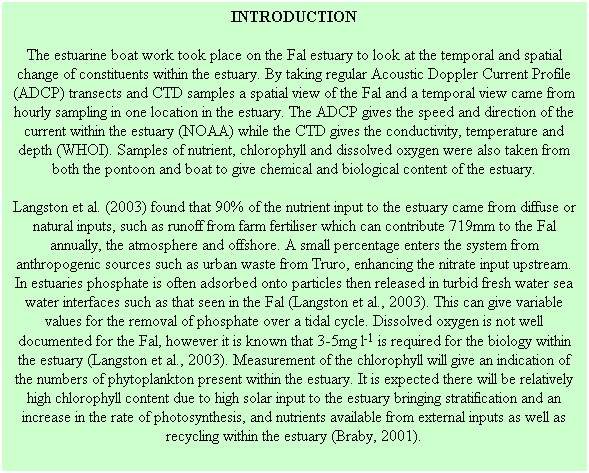
Braby, C.E. 2001, Phytoplankton blooms [online]. Available: http://www.mbari.org/staff/conn/botany/phytoplankton/phytoplankton_blooms.htm [accessed 2011, July 06th].
NOAA, Acoustic Current Doppler Profiler (ADCP) [online]. Available:
http://oceanexplorer.noaa.gov/technology/tools/acoust_doppler/acoust_doppler.html [accessed 2011, July 06th].
WHOI, Conductivity, Temperature, Depth (CTD) sensors [online]. Available:
http://www.whoi.edu/instruments/viewInstrument.do?id=1003 [accessed 2011, July 06th).](index_files/image029.gif)


![Text Box: Results
Both figures indicate a consistent, apparently anomalous, flow feature between 4&5m depth, indicating greater flow magnitude and divergent direction to ambient waters. This feature may indicate the presence of an internal wave, forced by pressure gradients generated by bathymetric change (Wells, N., 2011, pers. comm., 7th July). Its consistency over the transect within bins covering a two metre depth range may however indicate it as an artefact of ADCP operation (Statham, P., 2011, pers. comm., 7th July).
Large scale velocity magnitude patterns are clearly indicated in figure 39, with two regions of higher than average flow speeds of approximately 0.50-0.75 m/s. The first of these occurred in the shallower waters of between 16 and 25m depth, close to the Roseland Peninsula at the beginning of the transect (left of figure ?). The second region occurs in the middle of the transect where the bathymetry rises sharply to shallower depths of approximately 17m. This section of the transect is, like the first region, close to land, and just off the tip of a peninsula mentioned in the sea shanty ‘Spanish Ladies’ [time 1:11] called Dodman Point. Flow velocities in the rest of the transect were generally <0.4m/s, with flows to the east of Dodman point (right side of figure 39) typically less than those to the west.
The generally east north-easterly headed flow direction in the first region of increased velocity was little different from the slower moving water to its east, all the way to the approach to Dodman point. Here, in the faster moving shallower waters, the flow direction changed to head in a south-easterly direction, following approximately the orientation of the Dodman headland. To the west of Dodman point weaker flow velocities headed in a north north-westerly direction (red and purple region of figure ?). In a zone between these two contrasting flow directions of about 400m width and occurring throughout the water column just east of Dodman, flow travelled east. This indicates water moving, or being entrained, from the south-easterly flow into the region of northerly flow. These flow patterns indicate the movement of eddies of water in the bays both sides of Dodman point, with the water moving offshore of the headland originating in the west.
Conclusion & Discussion
The flow patterns demarcated by Dodman Point indicate the movement of eddies in the bays both sides of Dodman point, with the water moving offshore from the headland originating in the west. The data was recorded on an ebbing tide, when the net movement of water from the Western English Chanel will have been in the direction of the Atlantic. That the general flow recorded on the transect was to the east, particularly west of Dodman (i.e. contrary to the net tidally driven flow direction) indicate the presence of wind driven circulation patterns persisting over the tidal cycle. They may also however indicate residual tidal flow patterns particular to this region of the coastal sea. Admiralty charts provided no useful tidal diamond information for the area of interest and thus discriminating between these possibilities requires further investigation. This transect line should be repeated at different stages of the tidal cycle to examine local tidal effects, as well over a longer time series to identify the temporal persistence of the identified circulation patterns. Spatial coverage should also be increased to cover the areas inside the bays as well as further offshore.](index_files/image091.gif)