
![]() *
*
 *
*
 *
*

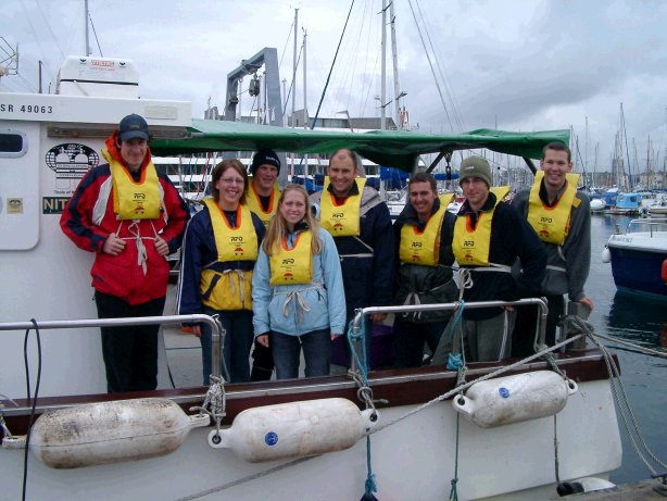
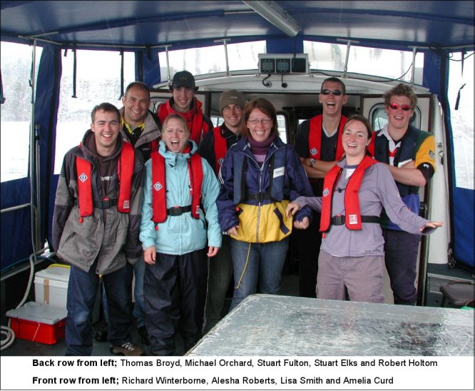
RIBs Terschelling Bill Conway Natwest II

|
This webpage presents the results of group eight's hard work, occasional mistakes and large amounts of vomit...... ......enjoy! |
|||||||||||
|
|
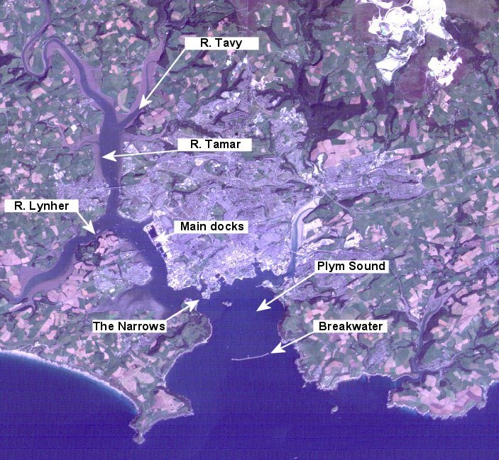
The River's Tamar, Lynher and Tavy all constitute part of the Tamar estuarine system, whilst Plymouth Sound forms the barrier between the estuary and the English Channel. The area covered by this report extends from Calstock, in the upper reaches of the Tamar, to just beyond the Eddystone Lighthouse, roughly 12 nautical miles south of the Plymouth breakwater (click on satellite image to see these locations) The estuary is a temperate, partially mixed Ria (meaning a drowned river valley). It forms a natural boundary between Devon and Cornwall and is 31km in length, from the upper limit of salinity ingression at Weir Head to 'the Narrows' (Tattersall et al, 2003). It has a mean tidal range of 3.5m (Tattersall et al, 2003), and thus falls into a meso-tidal classification, although values of more than 5m can be reached during spring tides.
|
||||||||||
|
Synopsis: The purpose of this field course is to develop a holistic view of the Tamar Estuary and Plymouth Sound system by taking into consideration the biological, chemical, physical and geological processes occurring within the area of survey, and also external processes if they indirectly influence the system. The data from the various boat surveys and sample collections will be viewed together, rather than as individual samples, allowing an overall view of the area from the highest extent of tidal influence as far out as the Eddystone Rocks. |
|||||||||||
|
Expectations: The following predictions regarding some of the key environmental variables have been made by studying the literature from previous studies of the area.
|
|||||||||||
| Date | Weather | Sampling | Tides | |
|
Thursday 24th June 2004 |
Sunshine and Showers |
|
CTD Probe, Plankton Tow, Secchi Disk, Water Samples, Anometer |
HW: 09:48 GMT (Calstock) LW: 15:45 GMT |
|
|
Introduction: The RIB practical was carried out on Thursday 24th June 2004, running from Calstock down river to the Tamar Bridge, sampling at 17 sites. Plymouth-Devonport tide tables showed high water to be at 09:38 GMT. The secondary port calculation for Cotehele added a +10min delay, therefore high water at Calstock was calculated as 09:48 GMT. The required water depth for the RIBs to navigate safely was 1.5m, and the lowest available water depth on that day was 1.8m; therefore we were not constrained by the tide. Two boats (Ocean Adventure RIB and the SRR vessel) were used for the survey. The samples collected from the RIBs were analysed by Group 7. The conditions on the day were variable, ranging from heavy showers to clear skies. The weather over the previous days had been continuously wet and windy. Having cruised up the Tamar to Calstock, observations started at 10.59GMT following the high tide at 09.48GMT at Cotehele. |
|
Objectives: The investigation aim was to collect biological, chemical and physical parameters of the water column throughout the Tamar Estuary. This should allow us to understand the variation in both abundance and diversity of the phytoplankton and zooplankton taken between the freshwater end member and the salinity found at the Tamar Bridge (ranging from 28-32) as well as the processes that cause this variation. |
|
|
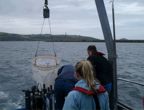
Equipment: Both vessels were equipped with Secchi disks, Anometers, T/S probes and Niskin bottles, but only the Ocean Adventure carried the Plankton net (mesh size 200µm, diameter 50cm). For the purposes of the physical observations an Anometer took the wind speed and the T-S probe also observed the changes in temperature and salinity within the water column. The probe on the SRR was not equipped with a depth sensor, therefore depth profiles were carried out at every other station, as the two boats “leapfrogged” down the river. |
|
|
Procedure: Salinity was the controlling factor in choosing the sample site. The initial decision was to sample at stations every 1.5 salinity units; however between site 9 and 10 it was decided that this would be changed to every 2 units as we wanted to make sure we overlapped with the measurements that Group 7 took on the Bill Conway. Each RIB sampled at every other site. A beaker was dipped into the water for the surface sample at each station which was used for all data analysis. Samples were taken with a 60ml syringe for filtering water 60ml into the glass Nutrient bottle and another 30ml for the plastic Silica bottle. The first two filters per site were kept and stored in test tubes containing 7ml Acetone for Chlorophyll analysis. Zooplankton samples were taken at 3 stations: salinity 16, 20 and 28. Each time the Ocean Adventure was moored to a buoy and the net was deployed for five minutes. Phytoplankton samples were taken at salinity 14 and 22 in glass bottles containing Lugols solution. All data was logged from the T-S probe, which included salinity, depth, percentage dissolved oxygen and pH. The Secchi disk reading was obtained by the same person each time, with cloud cover being noted at the time of lowering. The euphotic zone depth was then calculated by multiplying the Secchi disk depth by 3. Each RIB took one Niskin bottle sample by hand from the surface at salinities 14 and 20 for the oxygen samples. |
|
|
Results: The data collected from this RIB trip is not analysed on this website. This is because it is not possible to view a continuous profile of the estuary from Calstock to the Breakwater unless all the data is collected on the same day. The RIBs only travel as far as the Tamar Bridge and the Bill Conway travels from the bridge to the breakwater; as a result, it is necessary to use another group's data that has been collected on the same day. It was decided that this website should analyse the results collected by this group on Bill Conway and Group 7's RIB data as this was all recorded on the same day. This is all included in the Bill Conway section below. See Group 7's website for analysis of our RIB data. |
|
| Date | Weather | Sampling | Tides | |
|
Sunday 27th June 2004 |
Cloudy with some Sunny Spells |
 |
CTD Rosette, Plankton Tow, Secchi Disk, ADCP, Anometer, Water Samples, Minibat |
HW: 12.26 GMT (Devonport) LW: 18:48 GMT |
|
|
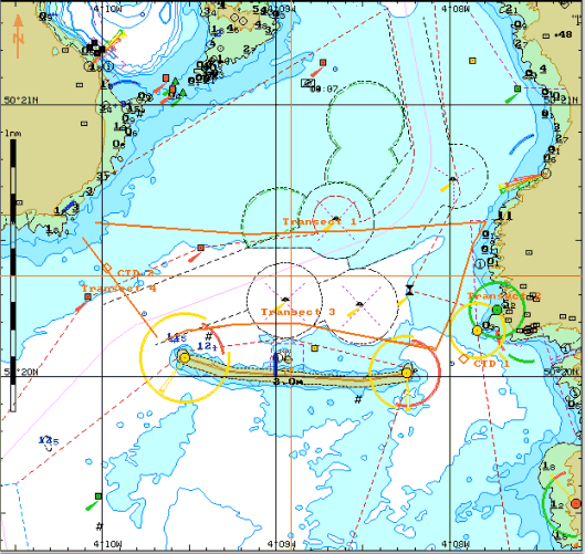
Introduction: We decided to sample at four sites; Our first site was sampled just off the breakwater at 50º 20.094N, 4º 08.075W as a practice run. Three sites were then sampled around Eddystone Rocks; the second sample was east of Eddystone Rocks (50° 11.00N, 4º 14.00W), the third was to the south (50º 10.00N, 4º 16.00W) and the fourth was taken between Eddystone Rocks and Hand Deeps (50º 12.00N, 4º 18.00W) (See Navifish image for more detail of the locations; all sites referred to from this point forward are on the map). The shipping forecast for Portland-Plymouth stated southwest force 4 or 5, occasionally 6, rain then showers. High water that day was at 12.26 GMT (Plymouth-Devonport) at a height of 4.5m and low water was at 18.48 GMT with a height of 1.9m. The previous day was a neap tide so all current rates were low.
|
||||
|
Objectives:
|
|||||
|
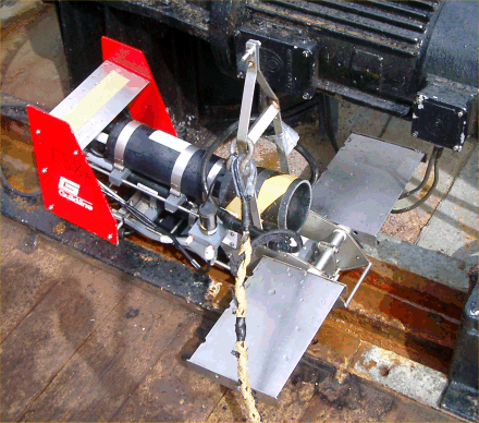
Equipment: The vessel had the following equipment; a closing zooplankton net (mesh size of 200μm, and a diameter of 50cm) which had the ability to be towed horizontally as well as vertically through the water column. A CTD with a rosette attached to the frame, which held five Niskin bottles. An ADCP was deployed on a metal pole over the side of the ship, as well as an echosounder to verify the depth readings of the ADCP. A Minibat was towed behind the vessel to monitor the physical characteristics. Finally a Secchi disk was used at each station. |
|||||
|
Procedure: The first site was inside the breakwater, where data was collected here to familiarise the group with the equipment. The remaining stations were chosen so that samples could be taken at three points around the island to build up an understanding of the effect of the rocks on the properties and structure of the water column. At each station the zooplankton net was lowered to depths which were determined by the data presented by the ADCP. The collection of the sample took place vertically as the net was bought to the surface. For samples to be taken at specific depths messenger weights were dropped down to the net, which triggered the closing mechanism. Secondly the Secchi disk reading was taken at every station which was used to calculate the euphotic zone depth (x3 secchi depth). The next stage required the lowering of the CTD down through the water column. The profile was then studied and as the CTD was slowly brought to the surface it was stopped at various depths of interest where one of the Niskin bottles was fired. These water samples were collected in a beaker, extracted and then treated in the wet lab on board for nutrient, oxygen and chlorophyll analysis (using a 60ml syringe for filtering water into the glass Nutrient bottle and another 30ml for the plastic Silica bottle. The first two filters per site were kept and stored in test tubes containing 7ml Acetone for Chlorophyll analysis.) |
|||||
|
|
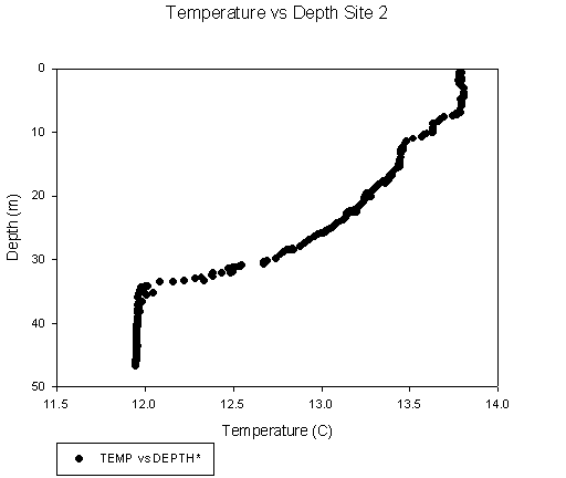
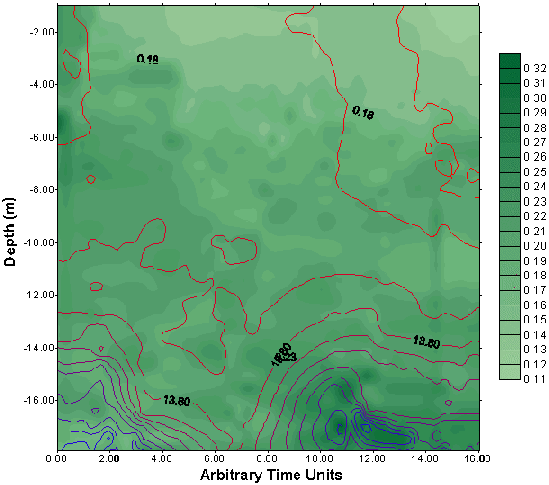
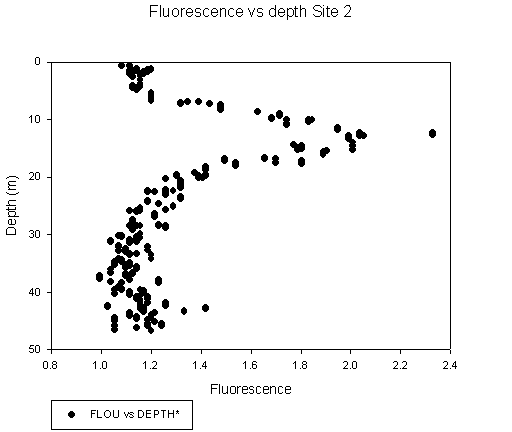
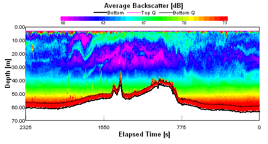
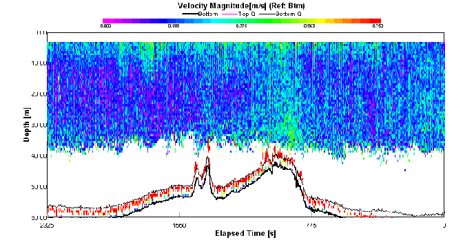
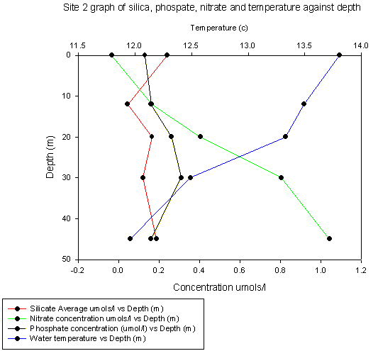
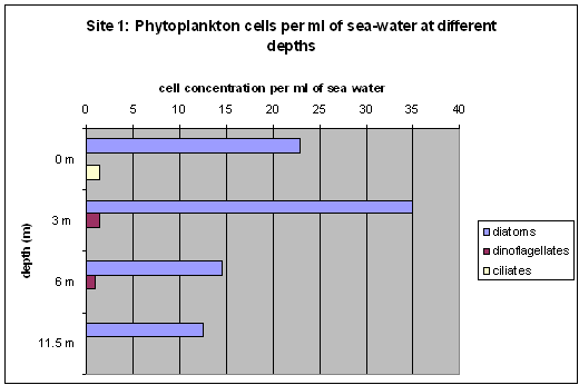
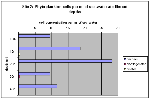
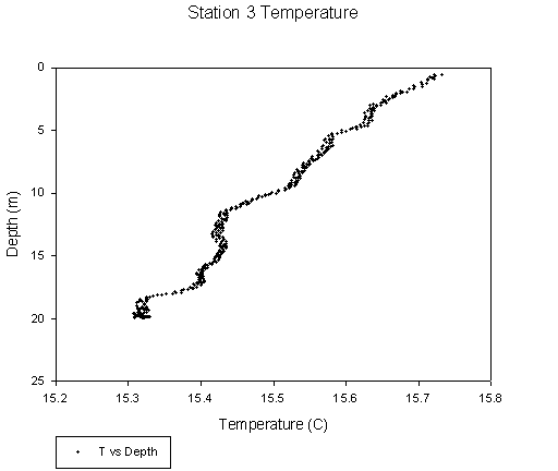
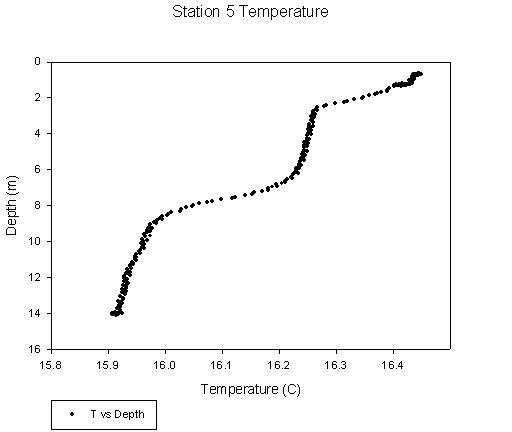
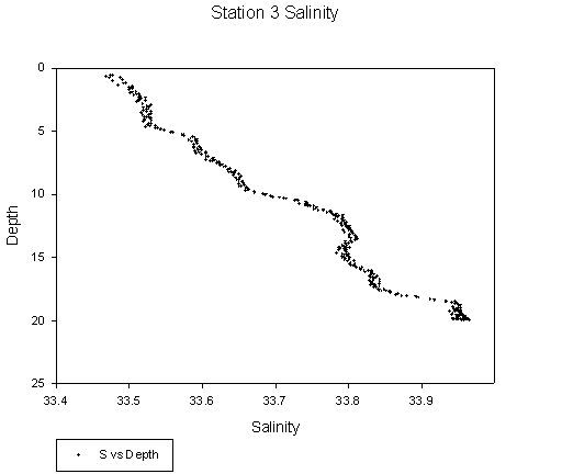
Results: Site 1 - Silicate concentrations are very low throughout the water column, with values not exceeding 0.22μmol/l. Phosphate values are also low, varying between 0.4 at the surface and 0.25 μmol/l. Nitrate levels decrease throughout the water column, from 0.85 μmol/l at the surface to 0.4 μmol/l at 11m, with the biggest decrease observed between 6 and 12m. The depth of maximum fluorescence is approximately 4-8m. However, the phytoplankton analysis shows a diatom concentration maximum at 3m, which is just above a clear thermocline at 4m. With increasing depth, it is seen that diatom numbers are halved between 3-6 m, even though the fluorescence maximum runs through both these points. The zooplankton trawl between 0-10m shows that almost 30% of the species composition is made up of copepods, with the next most dominant species being Noctiluca sp. dinoflagellates, hydromedusae, and siphonophores with 17.9%, 15.4% and 10.9% respectively.Site 2 - The silicate concentration for this site is low, varying between 0.05-0.20 μmol/l. Phosphate concentrations are again low, with values reaching no higher than 0.3 μmol/l. Nitrate concentrations increase with depth from 0.15 to 1.05μmol/l. There is a gradual decrease in temperature from 13.8oC at the surface to 12.0oC at 35m, below which it stays constant (link). Salinity, which is at a constant 35.22 above 35m increases to 35.26 below the thermocline. There is a sharp peak in fluorescence at 14m depth. Once again the highest diatom concentration is recorded at 20m, but this may be an error in the cell counts. The zooplankton trawl between 0-25m shows an abundance of copepods (38.2%), Noctiluca sp (27.1%) and globules of phaeocystis colonies (15.8%). At greater depth the zooplankton composition varies, with almost half the population being dinoflagellates, specifically Noctiluca sp. (33.5%) and Ceratium sp. (13.1%). Site 3 - The water column for site 3 is stable with increasing density with depth. Silicate levels are very low and show very little variation throughout the water column. The phosphate levels behave in a very similar way maintaining a constant concentration from top to bottom. The peak in nitrate within the euphotic zone (0-25) appears to correlate with peaks in diatom concentrations and fluorescence this might indicate the presence of active phytoplankton. The fact that oxygen levels are higher at 12m also supports this idea. Below the euphotic zone the nitrate levels increase rapidly and the oxygen levels drop, which coincides with an increase in Diatom concentration and fluorescence in the region of 40m. Species which dominate at this site include Noctiluca, Ceratium and other dinoflagellates. ADCP data for this site shows evidence of the effect of the Eddystone rocks, with flow velocity varying considerably along the ADCP track. Such behaviour is suggested in research by Pingree and Maddock, 1985. The ADCP backscatter data shows interesting patterns, with a peak very close to the surface, dropping sharply below 15m. Site 4 - Silica concentrations are low throughout the column as are phosphate concentrations. Nitrate concentrations reach a minimum at 12m only to increase with depth. Fluorescence peaks in the region of 20m and then decreases rapidly at 30m reaching a minimum at 45m. There is a noticeable transition zone between warm shallow water (10-0m) and cooler deeper water (from 30m down). The dominating Zooplankton species within this site are Copepods and Ceratium. There appears to be a slight increase in the silicate concentrations, after a small decrease from the surface to15 m. this increase is from 0.05 to 0.35 μmol/l. Phosphate concentrations show a similar trend for site 4 as in site 3. However the nitrate initially increases from the surface to15 m depth by 0.2 μmol/l, then it decreases to 0.05μmol/l at a depth of about 28 m. with further depth, the concentration is seen to increase again to 1.15μmol/l. There is no clear thermocline. Minibat - three sets of graphs were created with the data from each tow (temperature, salinity, fluorometry and transmissometry), all contour plots showing change in variables with depth along the Minibat track. Of the four, only temperature and fluorometry showed much variability with depth. Indeed, the characteristics displayed were much as expected, with a clear thermocline visible on tows 3 and 4 (8m and 10m respectively). The fluorometry (chlorophyll levels) profile for tow 4 showed higher levels at 12m depth; this behaviour was seen in the other profiles. In all cases, the points at which higher levels occur seem to correspond to the strong temperature gradients (as seen in the fluorometry, temperature profile). |
|
|
|
|
|
|
|
|
|
|
|
|
|
|
|
|
| Date | Weather | Sampling | Tides | |
|
Thursday 1st July 2004 |
Cloudy, occasional heavy showers |
|
CTD Rosette, Plankton Tow, Secchi Disk, Water Samples, Anometer, ADCP |
HW: 1644 GMT (Devonport) LW: 1035 GMT |
|
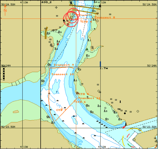
Introduction: On Thursday 1st July the R.V. Bill Conway collected data from just north of the breakwater up to the Tamar road bridge. In order to sample against the tidal flow (LW 10:35 GMT) and to be in “The Narrows” at slack water, we first headed out to the Breakwater, then sampled at “The Narrows” before heading directly to the Tamar bridge in order to sample downriver against the flood tide. The data collected included ADCP transects across selected river locations, vertical and horizontal CTD profiles and bottle samples for the analysis of Si, O2, NO3, PO4, and Chl.a concentrations. The data from the RIBs collected on the same day by Group 7, which was then analysed by our group, are quoted later in this section, as they give us a complete overview of the estuarine system on a particular day. The weather that day was variable, with scattered clouds in the morning followed by heavy showers in the afternoon. The wind was south-westerly, ranging between force 4 to 7. |
|
|
Objectives: The aim of the investigation was to obtain a full data set which runs from the upper reaches of the Tamar estuary down to the breakwater of Plymouth Sound, by combining the data obtained by the RIBs (Group 7) with our own. Their samples, which were then analysed by our group, are quoted later in this section, as they give us a complete overview of the estuarine system on a particular day. |
|
|
Equipment: Much of the equipment was identical to that used for sampling on the RIBs, which included a Secchi disk, T-S probe, plankton net (mesh size 200µm, diameter 50cm), and Anometer. Additional equipment on the Bill Conway included a CTD with 4 functioning Niskin bottles attached to the rosette frame. Finally an ADCP was attached to the boat which monitored underwater conditions continuously. |
|
|
Procedure: Our sampling strategy differed somewhat from that which we used on the RIBs (24.06.04), as our positioning was determined by the tidal state (see Introduction). We took water samples at depths chosen by looking at the upward CTD profile. Two plankton tows were carried out; the first just east of the breakwater, the second just south of the Tamar bridge. ADCP transects were recorded all around the breakwater, on either side of the Narrows, on either side of the Tamar bridge and at the confluence of the Lynher. |
|
|
|
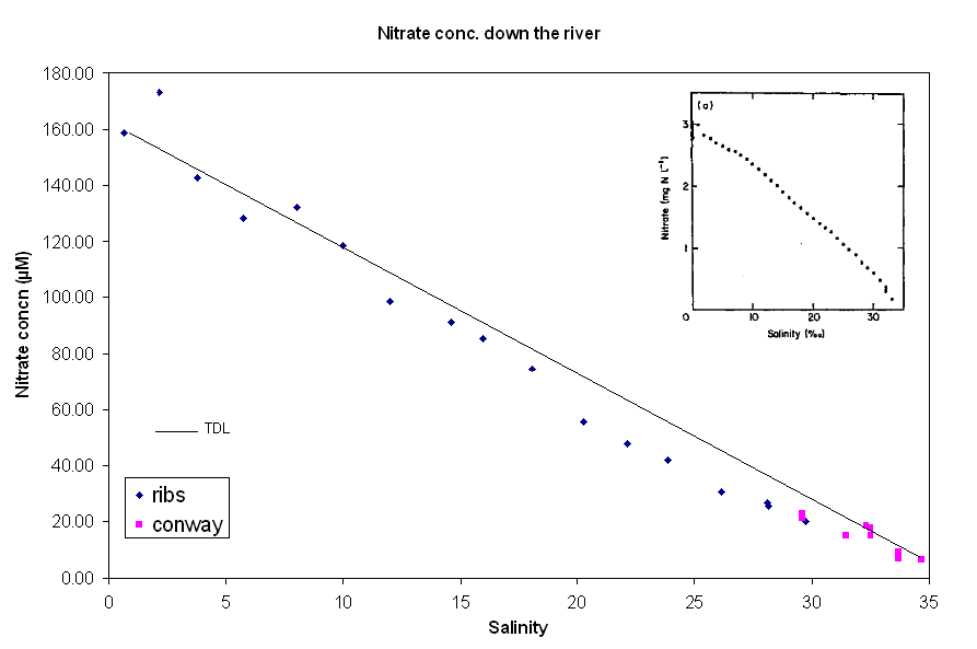
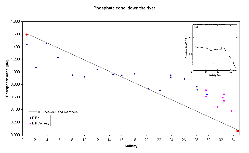
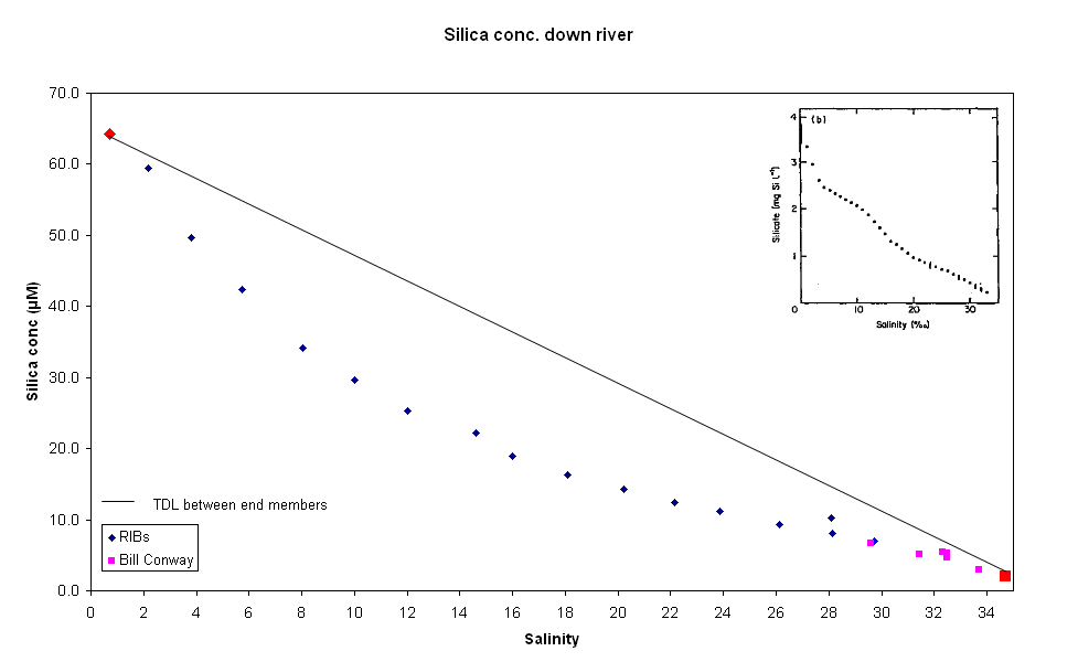
Results: Nutrients: The graph of nitrate vs. salinity shows a fairly linear relationship, with NO3 decreasing with increasing salinity, and with most points in close proximity to the trendline. Nitrate shows an essentially conservative behaviour in the Tamar estuary. Surface concentrations of silica show a non-conservative behaviour, with SiO2 decreasing with increasing salinity. The curvature of the graph is more pronounced at very low salinities, indicating that SiO2 removal was most effective in the upper reaches of the estuary (Morris, Bale & Howland, 1981).
Phosphate [PO4] appears to be removed in the upper estuary
(~S 1-14), added in the lower estuary (~S 14-30), and extremely low in the
seawater salinities. Previous studies have found that phosphate distribution
is independent of salinity in the Tamar due to inputs in the lower reaches
localized around the two tributaries, the Lynher and the Tavy. The unusual
distribution of phosphate may be due to pollutant sources arising from the
industrialised and urbanised regions in and around the city of Plymouth (Morris, Bale & Howland,
1981).
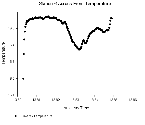
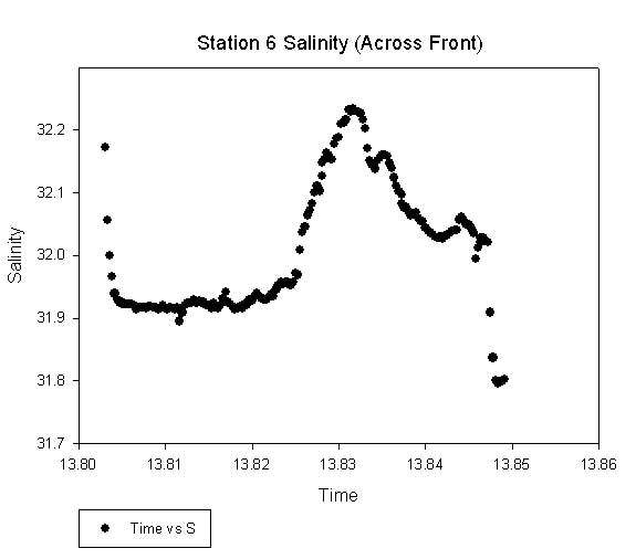
CTD Observations: At the point where
the
Tamar and the Lynher
converged a strong front was witnessed as seen in the
photograph to the right. The swirling area featured a clear line
of surface foam which was investigated by towing the CTD through the front
(CTD6).
The data revealed some interesting results. Either side of the front
temperatures were in the region of 16.55°C, however through the front,
temperature
decreased rapidly to between 16.3 and 16.36°C when plotted against time
shows a rapid increase in
salinity
from 31.95°C to 32.4°C across the front, which then drops off.
Interestingly, the fluorescence drops sharply at the front, where it would
have been expected to increase because of the higher nutrient availability. In
this case the feature is associated with the point where freshwater
encounters the incoming tide. This had the effect of producing turbulence
and upwelling, which produced bubbles at the surface. The presence of
seagulls circulating above this feature was an indication that nutrients and
food had been brought to the surface. In
the Narrows (CTD3 -
temperature,
salinity),
which were sampled 30min before slack water, the CTD and ADCP data
illustrate the movement of two opposing water bodies; the warmer, fresher
riverine water slides over the colder, denser seawater. The effect of the
Tamar's tributaries produces a localised "Double stratification" in both
temperature
and salinity (CTD4&5) which is caused by the different properties of the
rivers, such as catchment area and discharge.
The recent heavy rainfall could be the cause of the top ~3m of fresher
water, again this is just speculation as there are many possible
explanations to the water mass movements near confluences in tidal
estuaries. In
the Narrows, which were sampled 30min before slack water, the CTD and
ADCP data
illustrate the movement of two opposing water bodies; the warmer, fresher
riverine water slides over the colder, denser seawater.
Plankton:
The phytoplankton counts show a clear dominance of diatoms throughout the
salinity range with a peak of concentration at salinity 24. The samples
collected further up the river show more variation than the samples
collected on the Bill Conway where the salinity ranges were more uniform.
The zooplankton diversity increases with salinity and copepods, which were
the dominating species at low salinity, slowly give way to the
dinoflagellate Noctiluca. |
|
|
|
|
|
|
|
|
|
|
|
|
|
|
|
|
|
|
|
|
|
|
|
|
| Date | Weather | Sampling | Tides | |
|
Sunday 4th July 2004 |
Sunny spells, Calm sea conditions |
 |
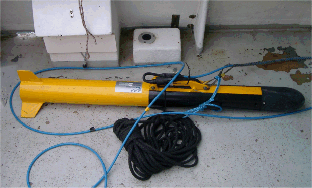
Van-Veen Grab, Side-scan sonar |
HW: 07.04 GMT (Devonport) LW: 13.17 GMT |
|
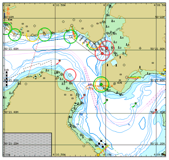
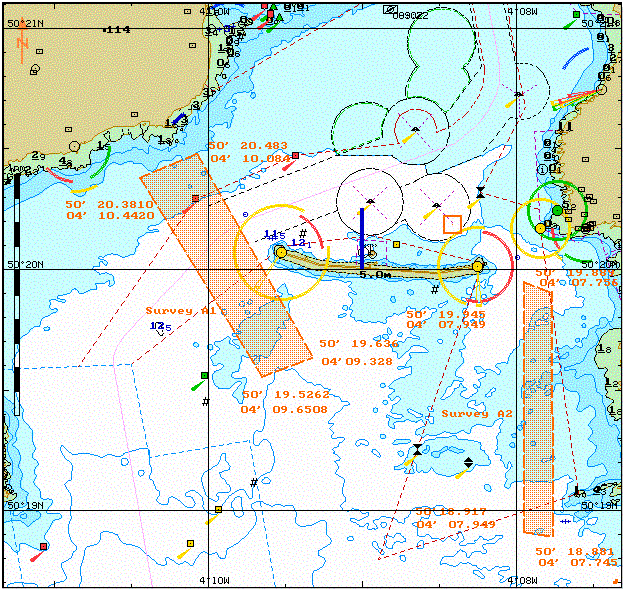
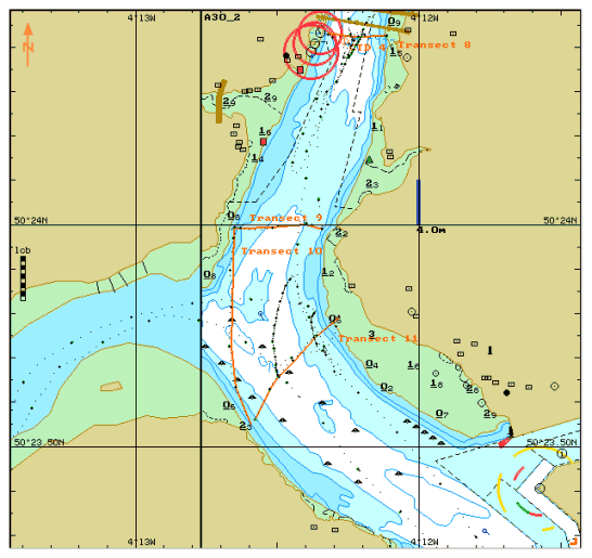
Introduction: On Sunday the 4th July 2004, the Natwest II collected two sets of transects from Plymouth Sound using a side scan sonar system. In order to avoid heavy sea conditions during the transects we decided to take transects on the west of the breakwater during the morning (survey A1), and to the east during the afternoon (survey A2). This was done as the shipping forecast suggested wind veering NW 4 to 5 becoming cyclonic force 3 in the afternoon, thus giving calmer conditions to the east later in the day. Several grab samples were collected in order to calibrate the side scan data by comparing the side scan signal with the sediment sample returned to the surface. The first set of samples started at 50o 20.425N, 4o 10.333W, and consisted of 8 transects, whilst the second set started at 50o 19.892N, 4o 07.754W and consisted of 4 transects. The full details including a map are shown at this link. |
|
||||
|
Objectives:
|
|||||
|
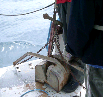
Equipment: The side scan sonar system used was a 500kHz GeoAcoustics system, consisting of a torpedo shaped fish that was towed roughly 1.5m behind the boat and approximately 1m below the surface. The grab samples were taken using a Van Veen type grab system that was triggered when it hit the seabed, taking a scoop from the sediment. |
|||||
|
|
|
|
|
|
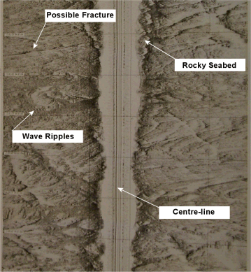
Results: West of Breakwater (survey A1): Close to the breakwater are wide channels in the bedrock in which can be found either cohesive very fine sand to mud areas (pale grey homogeneous patches on scan) interspaced with coarse-grained bioclastic sand displaying a ripple bedform. The ripples are sinuous in-phase and have a wavelength of 1.5m and an approximate wave height of 0.5m with a slight evidence of bifurcation, indicating wave influence. They are symmetrical, signifying an equal velocity of flow in both directions. Despite the predominant fetch coming from a southwesterly direction the ripples are orientated parallel to the breakwater; an interpretation could be that the waves refract as they pass over the bedrock. The waves could then reflect off the breakwater, creating these symmetrical ripples. In the centre of the wider bedrock channels there are strips of cohesive mud visible. An explanation could be that the highest current velocity being localised in the middle of the channel, the current scours away the coarser sediment, thus exposing the underlying anoxic mud. A very clearly defined fracture traverses all 8 transects; its orientation is unusual as it is perpendicular to the main fault lines in the area. East Breakwater (survey A2): Closest to the breakwater, the scan displays pale grey homogeneous areas indicative of fine sand, interspersed with areas of sinuous in-phase ripples approximately the same size as those on the eastern side. The ripples are orientated at approximately 45o to the track, or in real terms nearly perpendicular to the breakwater. It is possible that these are caused by ebbing tides flowing around the eastern side and being deflected by the bedrock into this area. The direction of these ripples supports this supposition. As the scan moves nearer to Renney Rocks the image becomes dominated by large areas of bedrock, varying from evenly distributed bedding to sharp rock outcrops considerably higher above the seabed. These are possibly indicative of a harder bedrock that is less easily eroded. In certain areas, gullies between rocks have been in filled with sediment and some show ripple waveforms. Two strong faults running roughly East-West are evident with 4-5m offset, and many fractures are seen perpendicular to these, as strongly defined lines. Q: Which is more effective, surveying parallel or perpendicularly to a fault? A: We found that it was much harder to detect the fault when surveying perpendicularly to it, as the sound does not get bounced back. Therefore it is best to plan the survey grid with the main lines of survey running parallel to the fault, with a few perpendicular tie lines to “double check” bedforms. |
|||
|
Overview |
|
The data collected from the boat work has allowed us to investigate many of the statements made within the published literature. In particular the findings from the data collected from the Bill Conway and RIBs have both been very useful, as clear correlations could be seen in the data. For example, the silicate data indicates classic non-conservative features. In addition to that, the phosphate concentrations reflect the removal of the nutrient at lower salinities, and with addition at higher salinities. It was also observed that nitrate showed conservative behaviour. Similar results have been observed in previous studies (Morris, Bale & Howland, 1981). For the data collected onboard the Terschelling, there appears to be little indication that the Eddystone Rocks having influenced the biology, in addition to that, all stations appeared to maintain visible thermocline’s. The chemical and physical structure remains fairly constant too. A majority of the data collected was accurate and allowed conclusions to be drawn; however some data or even equipment has induced errors in either the collection or analysis. Particular areas of concern include the dissolved oxygen plots taken from the Terschelling, since these display no useful results. A further dilemma to that is the lack of calibration files from the CTD data, which renders all the DO2% data invalid. To end, it is worth pointing out that there will be differing levels of accuracy in the raw data collected from various chemical analysis whilst on board Terschelling, due to the occurrence of ill health aboard! |
| NB: All other graphs not seen directly in this web page can be found in our group directory. |
| Reference List | |
|
Pingree, R.D. and L. Maddock (1985). Rotary currents and residual circulation around banks and islands. Deep-Sea Research. 32 (8), 929-947.
|
Siddorn, J.R., Allen, J.I. and R.J. Uncles (2003). Heat, salt and tracer transport in the Plymouth Sound coastal region: a 3D modelling study. Journal of the Marine Biological Association of the United Kingdom. 83 (4), 673-682. |
|
Fisher, N.R., Holligan, P.M., Hydes, D.J., Moore, C.M., Rippeth, T.P., Sharples, J. and J.H. Simpson (2001). Phytoplankton distribution and survival in the thermocline. Limnol. Oceanogr. 46 (3), 486-496. |
Morris, A.W., Bale, A.J. and R.J.M. Howland (1981). Nutrient distributions in an estuary: Evidence of chemical precipitation of dissolved silicate and phosphate. Estuarine, Coastal and Shelf Science. 12, 205-216. |
|
Tattersall, G.R., Elliot, A.J. and N.M. Lynn (2003). Suspended sediment concentrations in the Tamar estuary. Estuarine, Coastal and Shelf Science. 57, 679-688. |
|
