Plymouth field course
GROUP 5
| The group 5 website contains a summary of all the data collected over the duration of the field course. For the complete data set please see the files contained within the directories of the group 5 folder. |
|
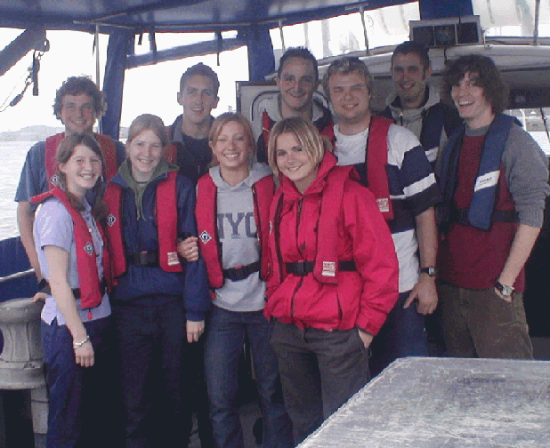
Fig. a and b. Group photo and artistic self portraits |
The Tamar estuary is a drowned river valley which consists of the main river and two tidal sub-estuaries: the Tavy and the Lynher. Plymouth is located in the South-west corner of the English county of Devon at the confluence of these three waterways. Plymouth Sound lies to the South and, along with the adjacent seas, was exposed to Southerly Atlantic gales until the construction of the freestanding breakwater in the 19th Century. Plymouth has a typical semidiurnal tide, the average range being 4.65m at the spring tide.
24/06/04
|
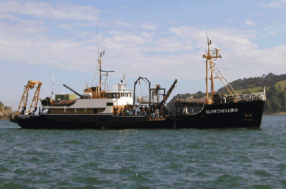
Fig. c. Terschelling |
To determine the influence of physical properties on the vertical mixing processes off Plymouth in order to assess the structure and properties of the plankton communities.
To survey the offshore region of Plymouth Sound. Several surveying plans were conceived to enable sampling to be completed irrespective of metrological conditions.
|
Plan A: a survey to be undertaken at L4, a position approximately 10 nautical miles south west off Plymouth. |
|
|
Plan B: a bad weather plan which detailed a transect to be conducted from the east end of the breakwater to Penlee point. The orientation of this transect was dictated by the protection afforded by headland to the west of Plymouth harbour. |
The weather on the day of sampling proved to be too hazardous to allow a full transect to the offshore station (L4) to be undertaken so Plan B was used. Plan B involved 4 stations with an approximate separation of 1/2 mile. Station 1 was the first point on the transect and it was also used as a 'shake-down' to check the newly acquired CTD was fully functional and to familiarise ourselves with the equipment and boat. Due to an increase in the swell in the region proposed for station 4, the site was moved to the western end of the breakwater. The influence on this decision was to allow a comparison between the eastern and western stations behind the breakwater to see if there was a favoured end for the accumulation of phytoplankton and the variation of physical properties.
Physical
|
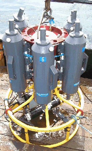
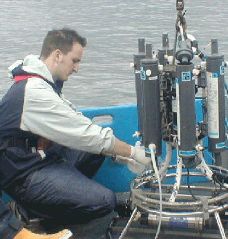
Fig. d. CTD rosette |
||||||||
Chemical
|
|||||||||
|
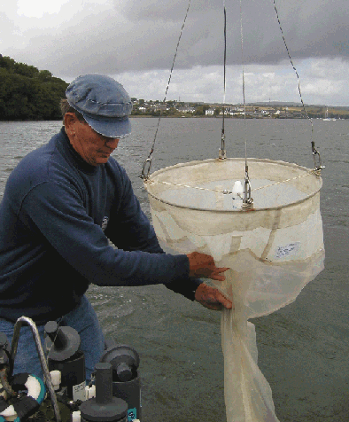
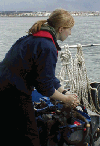
Fig. e. Bob and the Plankton net |
|||||||||
Biological
|
|
Position |
Time (GMT) |
Sampling Method |
Sampling Time (GMT) |
Depths Sampled (m) |
Other Notes |
|
50º20.197N 4º08.489W East end of breakwater (inside breakwater) |
Start: 0938 |
CTD |
0938 |
9.57, 5, 0 |
Weather: 5/8 cloud cover, Sunny spells. Wind: 20 knots Maximum Depth: 13m Sea: Calm, reasonable swell. Drift:100m |
|
Finish: 1050 |
Plankton net |
1035 |
10 |
||
|
Secchi disk |
- |
2.5 (sunshine) |
|||
|
ADCP Transect Carried out between stations 1 and 2 |
11:50 |
Table 1. Station 1 primary information.
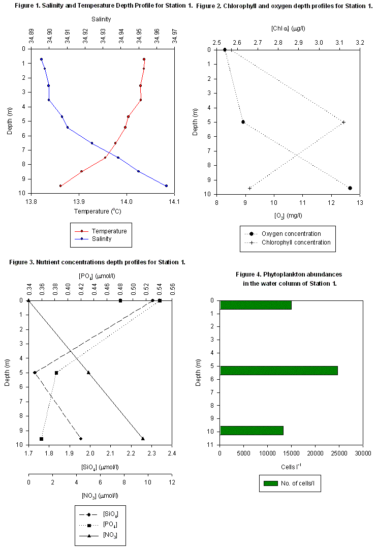
| Analysis The relatively constant temperature and salinity with depth shows there was mixing in the water column (Fig. 1). The weak temperature gradient was due to increased mixing caused by previous weather and greater river outflow. However there is evidence of slight stratification demonstrated by chlorophyll maximum at 5m (Fig 2), which is related to the greatest phytoplankton abundances. This depth also correlates with a silicate minimum (Fig. 3). The most probable explanation was provided by the analysis of the phytoplankton in the water column, which showed that the dominant species was diatoms that require silicate for growth and therefore higher numbers means more silicate is utilised. Diatoms tend to be the dominate species in eutrophic, turbulent and partially mixed water columns. (Kiorboe, T, 1993). The increased oxygen concentrations observed below 5m depth (Fig. 2) may result from increased levels of photosynthesis due to higher phytoplankton densities. |
Fig. 1-4. for station 1 |
|
Position |
Time (GMT) |
Sampling Method |
Sampling Time (GMT) |
Depths Sampled (m) |
Other notes |
|
50º19.501N 4º08.938W 0.5miles from station 1 towards west headland |
Start: 1059 Finish: 1132 |
CTD |
1103 |
9.5, 7, 4, 0 |
Weather: 4/8 cloud cover, sunny, Wind: 19 knots. Maximum Depth: 13.5m Sea: 1.5m swell |
|
Plankton net |
1117 |
10m to surface |
|||
|
Secchi disk |
1117 |
3.5 (sunshine) |
Table 2. Station 2 primary information.
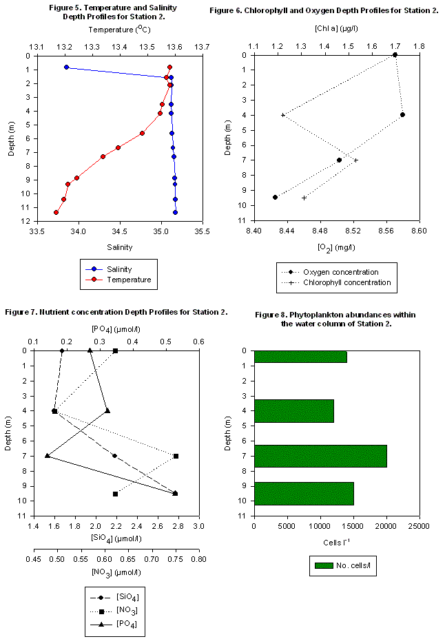
| Analysis An increase in the salinity just below the surface minimum of 33.85 can be seen in Fig. 5 and this could be attributed to previous bad weather, especially the effect of rainfall diluting the surface waters. The euphotic zone, as suggested by the Secchi disc depth, lies at approximately 10m. Within this, the water column was fairly well mixed and the temperature is seen to decrease with a marginal loss of 0.4oC (Fig. 5). This is a possible remnant of an earlier thermocline eroded by turbulence; this can be observed between 6 and 8m and repeat readings would lead to a better conclusion. The apparent minor thermocline coincides with a chlorophyll maximum and a phytoplankton maximum at 7m.(Fig. 6 and 8 respectively). The silicate and phosphate concentrations have an overall increase with depth with the silicate more than doubling in concentration from the surface to the bottom of the water column (1.03µmol/l to 2.85µmol/l). Nitrate concentrations fluctuates about 0.6217µmol/l, with a decrease being observed in the top 4m (Fig. 7).The nutrient concentrations in this zone decrease possibly due to its utilisation by the phytoplankton. The rapid decrease in oxygen levels of 0.16mg/l from 4m to 9.5m could be due to the relatively high zooplankton numbers as they would utilise the oxygen (produced by phytoplankton during photosynthesis) during respiration. |
Fig. 5-8. for Station 2 |
|
Position |
Time (GMT) |
Sampling Method |
Sampling time (GMT) |
Depths Samples (m) |
Other notes |
|
50º18.907N 4º09.611W |
Start: 1152 Finish: 1225 |
CTD |
1200 |
20, 12, 9, 0 |
Weather: 6/8 cloud cover. Wind: 24 knots Maximum Depth: 23m Sea: Choppy, 1.5m increasing swell |
|
Plankton Net |
1220 |
20m to surface |
|||
|
Secchi disk |
1220 |
3m (sunshine) |
Table 3. Station 3 primary information.
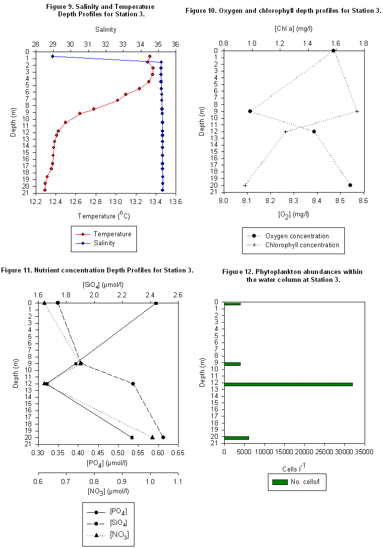
| Analysis Low nutrient concentrations exist at the surface (0.6 µmol/l) because phytoplankton have stripped the majority of nutrients during the spring bloom. These phytoplankton populations then sank and can be shown by a peak in chlorophyll concentrations (Fig. 12) and a minimum in oxygen concentrations (Fig. 10) at 9m. A discrepancy arises when comparing chlorophyll concentration to phytoplankton population as they peak at 9m and 13m respectively. The phytoplankton peak does however correspond to the nitrate minimum at 12m (0.6 µmol/l). Further samples through the water column would need to be taken to confirm this but a possible cause is the weather conditions. The reason for the biological and chemical profiles are related to the physical structure of the water column. There is a fairly pronounced thermocline between 4 and 10m which may have restricted some of the mixing of nutrients to the surface layers and led to the observed deep chlorophyll maximum and high nutrient levels below the thermocline. The slight density difference of 26.43 sigma-t/kgm-3 above the thermocline and 26.71 sigma-t/kgm-3 below it demonstrated the possibility for shear within the water column. The salinity is reduced in the upper 1.5m of the water column due to excessive rainfall, both the direct dilution effect and the increased river discharge resulting from rainfall over land. Then the salinity profile is predominantly constant with depth. (Fig. 9). |
Fig. 9 - 12. for Station 3 |
|
Position |
Time (GMT) |
Sampling Method |
Sampling time (GMT) |
Depths Sampled (m) |
Other Notes |
|
50º20.246N 4º09.484W Inside west end of the breakwater |
Start: 1255 Finish: 1317 |
CTD |
1258 |
11, 5, 0 |
Weather: 7/8 cloud cover. Wind: 16 knots Maximum Depth: 12m Sea: Choppy, 1m swell. |
|
|
Plankton Net |
1305 |
12m to surface |
||
|
Secchi Disk |
1305 |
2.5m (cloudy) |
Table 4. Station 4 primary information.
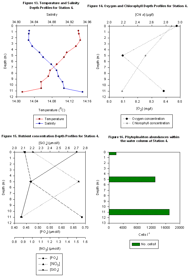
| Analysis The low levels of nutrients found in the surface waters correlate well with the maximum abundance of phytoplankton (17000 cells/l) in the same area, this is supported by both the direct measurements of phytoplankton numbers and by the maximum values of chlorophyll (2.88µg/l) in this region (Figs. 14 & 16). Also in the surface region there is the lowest levels of both nitrate and phosphate and there is a decrease in the dissolved O2 concentration. This can be accounted for in the same way as for the previous stations i.e. by an abundance of respiring zooplankton feeding on the phytoplankton populations within these waters. The water column appears relatively well mixed with temperatures generally decreasing with depth but with only a 0.13oC difference between the surface and bottom waters. Similarly, the increase in salinity with depth results in only a 0.12 difference between surface and bottom water salinities. Therefore it can be concluded that there is only a weak physical gradient present. (Fig. 13). The results for station 4 are very similar to station 1, the other end of the breakwater, therefore, in this survey, there is not a difference in the 2 ends of the breakwater. |
Fig. 13 - 16. for station 4. |
MiniBAT data
| The MiniBAT was used on a transect between stations 2 and 3. Looking at the backscatter readings from the ADCP in figure 17 it was clear to see a region of increased backscatter between 5 and 15m depth in the water column. Transmissometer and Flourometer readings from the MiniBAT were then used to determine the nature of this anomaly. The transmissometer showed a decrease in optical transmission indicating an increase in turbidity. However Flourometer readings indicated no significant change in chlorophyll concentrations for this same region. This therefore relates to a low phytoplankton population in this area. As a result it may be assumed that zooplankton populations in this area may also be small, and therefore may not account for the increased backscatter seen from the ADCP (figure 18). Therefore this backscatter may be caused by increased sediment concentrations that maybe the result of a change in current direction in this area as indicated in figure 19 from the ADCP. The sediment type in this region is predominantly fine sand and shingle, therefore it maybe possible that the finer material could have been re-suspended by the changing currents in this area. It may not be assumed that this area is a front as temperature and salinity changes from the MiniBAT profiles are negligible. |
Fig. 17 - 19. for MiniBAT and ADCP |
Fig. f. MiniBAT
At stations there is a general trend in the properties of the water column. Surface layers comprised a homogeneous structure resulting from wind and wave action. In the surface layer nutrients are stripped during spring blooms leading to a deficit and low phytoplankton numbers. It was observed that chlorophyll concentrations increase with depth with a peak located at the remnants of a thermocline. This is where nutrient levels are higher as a result of diffusion across the thermocline from deeper well mixed waters. The peak in net production occurs because the thermocline causes a stabilisation of the water column allowing the phytoplankton sufficient time in the surface layer to utilise the light energy. (Pingree, 1975). This is because it restricts the vertical mixing and migration of phytoplankton and zooplankton. The oxygen concentrations decrease with depth due to removal by both phytoplankton and zooplankton.
A stratified body of water does not necessarily form simultaneously over a whole area which means that the water column is mixed in one region and stratified in an adjacent region. (Pingree, 1975). It was observed that the strength of the thermocline and pyncnocline decreases closest to the shore and in turn the chlorophyll maximum becomes less apparent due to increased mixing of the water column due to a greater influence of tide, wide, waves and interactions with the sea bed in shallower waters. It is possible to hypothesis that further stations from Penlee point would lead to an increased horizontal temperature known as a front which can occur where deeper stratified waters meet shallower tidally mixed waters. Other factors such as antecedent weather conditions, fresh water runoff from tributaries and wind strength also affect the amount of mixing within the water column and hence the location of this front.
RIB's REPORT
27/06/04
|
Fig. g. Coastal research |
Fig. h. Ocean Adventure |
The aim of both the RIB's and Bill Conway was to study and develop an understanding of how the Tamar Estuary acts as a transition zone between the fresh water inputs of the River Tamar and its associated tributaries and the coastal sea.
This practical involved sampling the upper estuary (lower salinities) using the RIB’s Coastal Research and Ocean Adventure whilst samples were taken for the lower estuary (higher salinity) by Group 6 aboard the Bill Conway. To demonstrate physical, chemical and biological changes between riverine and coastal waters and the interaction of the estuary and the adjacent land.
Sampling was completed on the 27/06/04 at sites along the River Tamar from 0-30 salinity, approximately every 2 salinity units. The two vessels used (Coastal Research and Ocean Adventure) conducted sampling at alternate sites along this transect. At each site a T/S probe (measuring temperature, salinity and oxygen concentration) was used to collect vertical profiles of the water column. Surface water was sampled to establish the levels of various nutrients relevant to the study (i.e. NO3, SiO4 and PO4). The silicate filters used in the collection of the nutrient water samples were retained within acetone filled polypropelene tubes to allow measurement of chlorophyll levels at each of the sampling sites. Both zooplankton and phytoplankton samplings were completed to examine the change in community structure and population density in both groups with distance along the Tamar from the riverine to estuarine conditions. Zooplankton sampling was completed by the Ocean Adventure where the suspended sediment load was low enough to permit effective use without clogging the mesh. Sampling of the plankton populations were completed by both vessels over a range of salinities.
High tide: 1326 GMT at Plymouth
1346 GMT at Cotehele
|
Station |
Time (GMT) |
Latitude |
Longitude |
|
1 |
11.34 |
50º30.258 N |
04º11.576 W |
|
2 |
10.22 |
50º29.736 N |
04º12.410 W |
|
3 |
12.09 |
50º29.529 N |
04º12.284 W |
|
4 |
11.14 |
50º29.751 N |
04º12.482 W |
|
5 |
12.23 |
50º29.891 N |
04º12.958 W |
|
6 |
11.38 |
50º29.852 N |
04º13.277 W |
|
7 |
12.38 |
50º29.418 N |
04º13.403 W |
|
8 |
12.06 |
50º28.938 N |
04º13.056 W |
|
9 |
13.05 |
50º28.632 N |
04º13.046 W |
|
10 |
12.29 |
50º28.397 N |
04º13.400 W |
|
11 |
13.18 |
50º28.123 N |
04º13.981 W |
|
12 |
13.01 |
50º27.400 N |
04º14.062 W |
|
13 |
14.00 |
50º28.001 N |
04º13.386 W |
|
14 |
14.19 |
50º26.981 N |
04º12.350 W |
|
15 |
14.26 |
50º26.648 N |
04º12.179 W |
|
16 |
14.31 |
50º26.240 N |
04º11.786 W |
Table 5. RIBs stations' primary information.
Physical Structure
| The Tamar estuary is macrotidal and therefore has strong tidal currents which generally results in a well mixed water column. The samples from the earlier stations were subject to stronger water currents from the flooding tide and so the development of a thermocline was prevented. Evidence of stratification was found during high tide at slack water (Fig.21) when the current velocities were weakest. However, the thermocline and pycnocline were both weak and so were easily disrupted by tributaries. The riverine end of the estuary is seen to be generally warmer (Fig. 20) than water found in Plymouth Sound (Figs. 22 and 23); this is expected due to the relative warming of river water in summer. A stable thermocline and pycnocline was observed just north of the breakwater (Fig. 22), where it was protected from disruption created by wind and tide, allowing a stratified water column to develop. In comparison, station 6 was unprotected and as a result showed a mixed profile. Figure 23 shows 2 separate water masses combining around Drakes Island. This is shown by Salinity and temperature spikes at 4 and 10 metres. |
Fig. 20 and 21. for station 1 and 9.
Fig. 22 and 23. for station 25 and 6 |
|
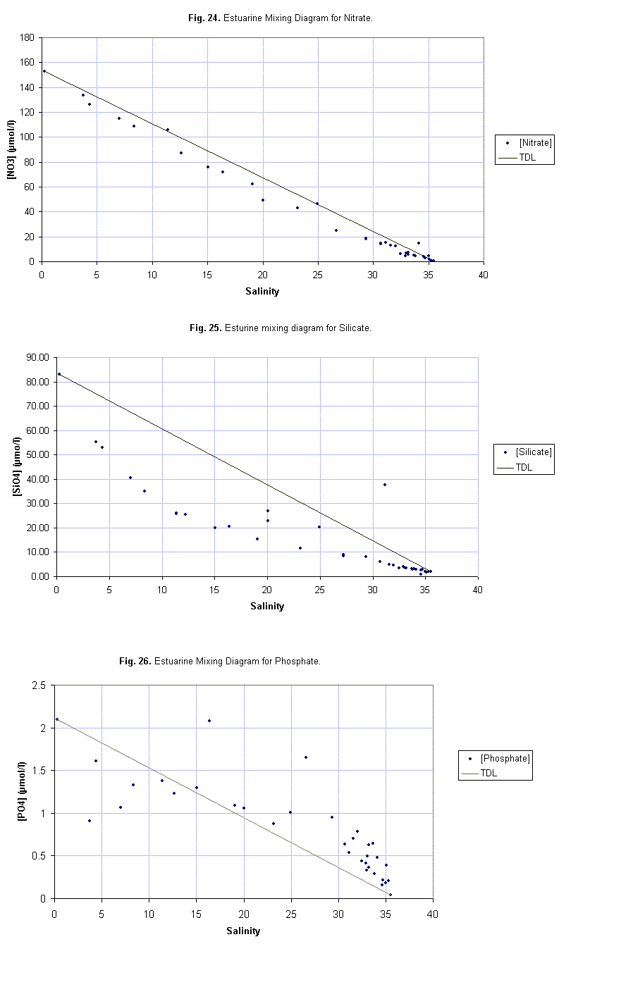
Nitrate shows non-conservative behaviour between the fresh water and saline end members, demonstrating slight removal of nitrate by marine organisms (Fig. 24). Agricultural and residential can cause addition of nitrate at some locations due to possible leaching of soils and surface runoff of inorganic fertilisers and ammonia.
Silicate also shows removal because it is the main nutrient utilised by diatoms in the construction of the hypotheca and epitheca which together form their frustule (Fig. 25). A secondary cause of silicate removal is related to the amount of suspended material present, affecting flocculation and adsorption processes, creating a non-conservative profile (Morris et al, 1981). There may be some addition of silicate at higher salinities caused by the degradation and recycling of diatom cells.
Phosphate distribution along the estuary implies that there is removal at the fresh water end and addition towards the seawater end (Fig.26). The removal of phosphate in the lower salinities (from 4.36 to 12.36) is caused by phytoplankton uptake. However between salinities of 15.06 and 36.4 there is addition of phosphate reaching concentrations of up to 0.122µmol/l. Anthropogenic influences may account for these inputs, which possibly corresponds with agricultural activity (e.g. Southward Farm) along the banks and also discharge from a sewage farm at Warren Point. Morris et al (1981) found that tributaries and anthropogenic additions in the lower estuary had a major influence on the distribution of phosphate whilst only exerting minor localised effects on the distributions of nitrate and silicate. This supports our findings of phosphate addition in the lower estuary. |
Fig. 24 - 26. Estuarine mixing diagrams |
Biology
|
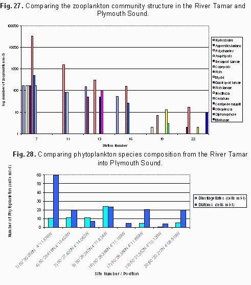
The zooplankton samples collected along the River Tamar show a decrease in species diversity and abundance moving seawards (Fig. 27). There is a change in the community structure closer to the head of the River Tamar and out in Plymouth Sound seen in samples 19 and 22. This change could reflect the fact that higher salinities are less subject to fluctuations than those seen up river where there are greater perturbations as a result of tidal flows and mixing of sea water with fresh water. The two dominant phytoplankton species found in the River Tamar and Plymouth Sound are Diatoms and Dinoflagellates. Numerous flagellates were also found in the phytoplankton samples however these were not included in the counts because of their small size which caused difficulty in identifying them. The highest concentrations of phytoplankton populations and chlorophyll were found high up the River Tamar in regions of lower salinity. However, no clear trends can be identified in the numbers or dominance of a particular species on a spatial scale. The constraints on phytoplankton growth are different according to their location either in the River Tamar or Plymouth Sound.
There is a correlation between phytoplankton and zooplankton numbers. Zooplankton numbers increase when there is increased food availability in the form of high phytoplankton concentrations. |
Fig. 27 & 28. Biological information on R. Tamar and Plymouth Sound. |
Nutrient concentrations decrease with salinity approaching the mouth of the Tamar estuary. The nutrients decrease downstream because of increased utilisation in the upper estuary by primary producers. The decreasing nutrient concentrations cause the phytoplankton numbers decrease proportionally. Zooplankton grazing on these phytoplankton subsequently also reduce in numbers. Antecedent weather conditions caused turbid waters in the upper estuary preventing oxygen analysis because of the high sediment load. These inclement conditions caused increased mixing of the water column and as a result a generally less stratified water column was observed than expected for this time of year. Variations in the observed suspended particulate matter may be because of changes in the local bathymetry, sediment type, current flows and localised inputs.
4/07/04
|
Fig. i. Bill Conway |
There were four main aims of this investigation:
|
To produce estuarine mixing diagrams for the nutrients silicate, phosphate and nitrate to look for evidence of addition or removal. |
|
|
To study changes in the dissolved oxygen concentration along the River Tamar. |
|
|
To study how the Rivers Lynher and Cattewater, inputs from land run-off and anthropogenic sources influence the biological, chemical and physical parameters from the upstream region of the River Tamar out into Plymouth Sound. |
|
|
To understand the main dynamic physical processes in the Tamar estuary using ADCP data. |
Surface water samples were collected approximately every 1 salinity unit to look for conservative and non-conservative behaviour of chemical species and to find out how this behaviour is mediated. ADCP transects accompanied by a CTD drop were used to provide an insight into the horizontal and vertical structure of the water column. Transect lines were conducted at a number of stations:
|
Across Plymouth Sound behind the breakwater |
|
|
Across the mouth of the River Cattewater |
|
|
At the confluence of the Rivers Lynher and Tamar |
|
|
At 3 points up the River Tamar. |
BiologicalThe regional change in the biological structure from the lower salinity areas influenced by freshwater input to the predominantly marine environment out in Plymouth sound was studied by using a zooplankton trawl and by collection of phytoplankton samples. High salinity samples were taken out by the break water and a phytoplankton sample was collected close to the Tamar Bridge to provide a lower salinity representative. To look at the influence of the input of fresh water on the structure and numbers within the plankton community a second zooplankton and phytoplankton sample was collected from the River Lynher. Chlorophyll samples were collected by filtering 60ml samples of surface water and retaining the photosynthetic material left on the filter, which was preserved using acetone. |
Fig. j. Niskin bottle samples |
||||||||
|
Physical Two methods were employed to study the physical structure of the water column: 1. ADCP 2. CTD The ADCP transect data was used to look at the water flow velocity, current direction and the level of backscatter in the water. The data provides information on the mixing processes that occur and can be used to look at the influence of inputs from the River Lynher and River Cattewater on the physical structure of the water column. The backscatter data can provide information on the level of primary production and suspended particulate matter within the water column. When the CTD was lowered it provided a vertical profile of the change in salinity with depth. |
Fig. k. Winch Wench |
||||||||
ChemicalThe following chemical components of the water column were analysed by collecting water samples using Niskin bottles attached to the CTD rosette fired at specific depths which enabled the observation of patterns associated with changing salinity and the effects of other components which were:
Oxygen samples were collected with the Niskin bottle to prevent contamination with atmospheric air. The nutrient data is required to produce estuarine mixing diagrams of the change in nutrient concentration with salinity. |
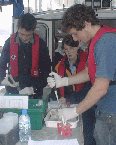
Fig. l. Chemical sampling |
|
Station |
Start Time (GMT) |
Start Position |
End Time (GMT) |
End Position |
Activity * |
||
|
Latitude |
Longitude |
Latitude |
Longitude |
||||
|
1 |
0857 |
50°20.229N |
4°09.823W |
- |
- |
- |
CTD |
|
2 |
0916 |
50°20.557N |
4°10.076W |
0932 |
50°20.577N |
4°07.779W |
ADCP |
|
3 |
0937 |
50°20.171N |
4°08.106W |
- |
- |
- |
CTD |
|
4 |
1003 |
50°20.216N |
4°08.169W |
1006 |
50°20.266N |
4°08.169W |
PN, SS |
|
5 |
1019 |
50°21.562N |
4°08.162W |
1026 |
50°21.728N |
4°08.197W |
ADCP |
|
6 |
1024 |
50°21.630N |
4°08.200W |
- |
- |
- |
CTD |
|
7 |
1049 |
50°21.706N |
4°08.564W |
1051 |
50°21.720N |
4°08.579W |
ADCP,SS |
|
8 |
1055 |
50°21.683N |
4°08.520W |
1058 |
50°21.689N |
4°08.476W |
ADCP,SS |
|
9 |
1113 |
50°21.592N |
4°10.069W |
1116 |
50°21.517N |
4°10.239W |
ADCP |
|
10 |
1133 |
50°21.788N |
4°11.272W |
- |
- |
- |
CTD |
|
11 |
1210 |
50°22.906N |
4°11.448W |
- |
- |
- |
SS |
|
12 |
1213 |
50°23.184N |
4°11.651W |
- |
- |
- |
SS |
|
13 |
1230 |
50°23.970N |
4°12.650W |
- |
- |
- |
SS |
|
14 |
1220 |
50°23.679N |
4°12.230W |
1223 |
50°23.544N |
4°12.520W |
ADCP |
|
15 |
1224 |
50°23.566N |
4°12.570W |
1229 |
50°23.971N |
4°12.641W |
ADCP |
|
16 |
1232 |
50°23.977N |
4°12.625W |
1232 |
50°23.968N |
4°12.341W |
ADCP |
|
17 |
1235 |
50°23.998N |
4°12.468W |
- |
- |
- |
CTD |
|
18 |
1247 |
50°23.791N |
4°12.781W |
- |
- |
- |
CTD |
|
19 |
1308 |
50°23.691N |
4°12.468W |
- |
- |
- |
CTD |
|
20 |
- |
- |
- |
- |
- |
- |
SS |
|
21 |
1324 |
50°24.510N |
4°12.287W |
1325 |
50°24.491N |
4°12.135W |
ADCP |
|
22 |
1329 |
50°24.595N |
4°12.245W |
- |
- |
- |
CTD |
|
23 |
1344 |
50°23.763N |
4°13.107W |
1347 |
50°23.706N |
4°13.224W |
PN, SS |
|
24 |
1416 |
50°21.542N |
4°10.216W |
1419 |
50°21.593N |
4°10.097W |
CTD |
Table 6. Bill Conway primary station information
|
Activity |
Abbreviations |
|
ADCP transect |
ADCP |
|
CTD dip |
CTD |
|
Plankton Net Trawl |
PN |
|
Surface Samples (using pump) |
SS |
Table 7. Key for abbreviations
|
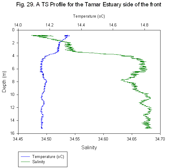
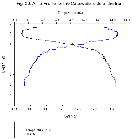
In Plymouth Sound the water column was well mixed, with no, or a very weak thermocline or pycnocline present, this pattern continues up the Tamar Estuary to the most upstream station at the Tamar Bridge. A front found at the confluence of the River Cattewater tributary and the Tamar Estuary shows two distinct water masses. The Tamar Estuary shows a well mixed water column with a surface layer of fresh water (Fig. 29); which meets the River Cattewater water mass, which is a stratified water column with a clear thermocline and pycnocline between 2 and 5 metres and between temperatures of 15°C – 14.2°C and salinities of 34.5 -35.5 respectively (Fig. 30).This suggests that while Cattewater is stratified, the Tamar Estuary is well mixed, which may be accounted for by its larger volume and numerous tributaries, both of which disrupt stratification.
|
Fig.29. T/S profile for tamar side
Fig. 30. T/S profile for Cattewater side |
Oxygen samples were taken at a number of stations. Both stations 6 and 10 were super-saturated with regards to dissolved oxygen and this can be related to the land use in the surrounding area. At station 6 there was a marina where industry and human activity were present, most notably a fuel refinery. At station 10 the significant land use was a naval docks on the East shore and a town on the West shore with evidence of agriculture and a re-fuelling area. The run-off from these activities is most probably stimulating phytoplankton growth and so an increase in photosynthesis is likely to be responsible for the increase in dissolved oxygen within the water. Station 6 was chosen for its proximity to the confluence with Cattewater, a source of fresh water and most probable source of nutrients which again, would stimulate phytoplankton growth thus raising oxygen levels in the water. Conversely, station 22 is subject to large inputs of nutrient from outfall pipes and the local sewage works which is further upstream and has marked discharge pipes on local charts for the area. With this taken into consideration the dissolved oxygen concentrations would expect to be higher as is the case with stations 6 and 10. This could be as a result of large zooplankton populations in this area, which would have the reverse effect of phytoplankton as they would utilise the dissolved oxygen in the water during respiration. However, this is speculation as zooplankton abundance is not known at this station.
|
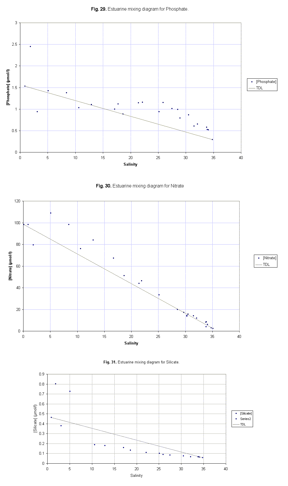
Phosphate being added to the River Tamar can be observed between the meander just south of Pentillie Castle (salinity 17) and at the seaward end member (Fig. 31). This may due to anthropogenic inputs from various agricultural activities as well as effluent from a local sewage plant located near Warren Point. At lower salinities, biological removal was observed previously in the RIB's data. The scatter of the data points in fig. 31 may be influenced by local inputs (Northward and Southward Farms) but it is more likely that the inconsistency is caused by errors in collecting and processing the concentrations.
Nitrate shows non-conservative behaviour along the estuary. There appears to be consistent addition of nitrate along the entire estuarine transect (Fig. 32). This is due to leeching of inorganic fertilisers and anthropogenic inputs from domestic waste in close proximity to the estuary (Southward farm).
Silicate illustrates non-conservative behaviour with considerable removal along the estuary (Fig. 33). The most probable cause of removal of silicate is by diatom assimilation, although there may be other processes contributing to the removal. These results correlate with previous findings from the RIBs data. There are a number of anomalies in the data; which may be due to external inputs, close analysis has not found any probable causes of this. These data points are thought to be due to errors in collecting or processing the samples and can therefore be classified as outliers and disregarded. |
Fig. 31 - 33. Estuarine mixing diagrams |
Biological
|
The phytoplankton data for the lower part of the estuary shows a significant increase in cell numbers after the confluence of the Lynher and the Tamar. There are two possible explanations for these results:
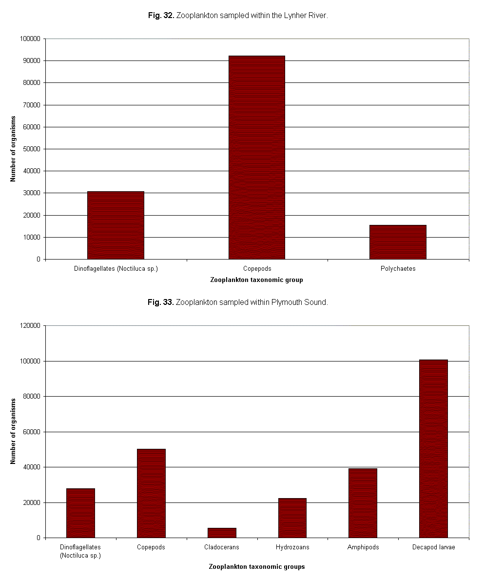
The two zooplankton tows have been used to compare the diversity and number of zooplankton in the River Lynher and the Sound (Fig 34). In a cursory investigation of the more saline waters of Plymouth Sound observations show higher diversity with twice as many taxonomic groups being identified than in the brackish waters at the mouth of the River Lynher. The tow from Plymouth Sound shows decapods as the dominant group but copepod numbers in the Lynher were higher than any other species. In comparison to data collected by groups 5 and 6 on 27//04, these results are notably higher but seem to correspond with the trends shown in the data collected by other groups. |
Fig.34. Phytoplankton numbers |
|
The transect gp5001r across the sound showed increased flow at the east side of the breakwater as seen in figure 35. This flow regime is present due to the ebbing tide through the main channel of the sound and inputs from the all the rivers in area. |
Fig. 35. showing ADCP transect across Plymouth Sound with increased flow at the east end of the break water. |
|
In the transect across the Cattewater two distinct water masses are present, there is a westward flow at the surface from the river and a slight eastward flow at the seabed most likely overflow from the Tamar channel (fig. 36). There is a peak in backscatter at 2.4m which correspond to an observed increase in flourometery indicating high phytoplankton stocks (fig. 37)
|
Fig. 36. Showing the transect across the mouth of the Cattewater with the two different flow directions. |
|
Fig. 37. Showing the backscatter from the transect across the mouth of the Cattewater with the two masses |
|
| While moving from the Cattewater to the Tamar a front was observed and sampled with the CTD to obtain a T/S profile (physical structure). The front is seen as an increase in the level of backscatter at the surface due to biological debris (fig. 38). The backscatter is caused by the convergence of two water masses. The front also shows a tongue of Tamar water pertruding into the Cattewater from the overflow of the Tamar from its channel (fig. 39). |
Fig. 38. Showing two water masses moving towards each other with a transect over a front. |
|
Fig. 39. A transect over a front using backscatter to show up the precise position. |
|
| At the corner by Buoy Wharf the transect showed a rather surprising phenomenon, where the velocity magnitude was greater over the inside of the meander and slower on the outside (fig. 40). This may have been caused by the presence of a rubble bank on the inside of the estuary. This is where the flow is separated at the surface and this is uninterrupted by the bank so it carries on in the same southerly direction. The main body of the flow that was forced to change direction as it hit the rubble bank was therefore slowed down. |
Fig. 40. Showing flow regime at Buoy Wharf. |
| The transects across the Tamar showed nothing unexpected with a thalweg (increased flow) present in the main channel and slack water around the banks. However the transect across the Lynher showed an interesting eddy (fig. 41). This may have been caused by the smaller flow from the Lynher hitting the larger flow of the Tamar and rebounding off it. |
Fig. 41. Flow direction at the mouth of the Lynher. |
NB. Further analysis of this ADCP will take place in Southampton
The estuarine mixing diagrams (Figs. 31-33) show similar behaviour patterns to that found in the RIB practicals for the lower Tamar estuary. Silicate is removed, most probably by biological processes, which is supported by findings of high numbers of diatoms. Nitrate and phosphate also undergo removal; again this is thought to be biologically induced.
Oxygen concentrations are found to correlate closely with biological activity at the majority of stations. At areas of high nutrient concentrations, found at river confluences and near anthropogenic inputs, biological activity in the form of primary production is found to increase and oxygen levels increase as a consequence. It is thought that the low oxygen levels found at station 22, despite high phytoplankton concentrations is caused by increased numbers in the zooplankton communities although there is no data available to ascertain if this is the actual cause.
The ADCP data shows the water flow in the Tamar estuary is highly variable, this is primarily caused by the convergence of water masses and local bathymetry.
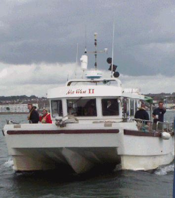
NATWEST II REPORT
1/07/04
|
Fig. m. Natwest |
Fig.n. Side scan sonar fish |
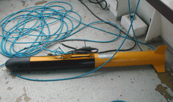
| The aim of this survey was to study the influence of current flows on the bedforms at the confluence of the River Lynher with the River Tamar using a side scan sonar fish (fig. n.). The side scan sonar operated at 500 kHz which provided high resolution over a small area which was required for our study. |
| On the 1st July 2004 Group 5 jumped aboard the good ship Natwest 2 in order perform a side-scan sonar survey to map the geophysical features from 50o 23.4337N, 4° 12.1967W to 50° 23.8700N, 4° 12.8481W (fig.42) |
Fig. 42. Location of the confluence of the River Tamar and River Lynher including the ADCP transects. |
The geophysical transect locations for side scan, grabs and ADCP
|
Figure 43 shows an ADCP transect from group 6 on 27/06/04 from Carew Pt to Kinterbury Pt. Here it is possible to see increased flow in the central channel between ensemble number 1532 and 1747 of approximately 0.4m/s. Towards the banks a reduced flow can be observed of around 0.0 to 0.1m/s. This flow regime explains the geomorphological structures as observed by the side-scan sonar. For example, figure 44 shows some linear megaripples normal to the current direction with a wavelength of`6m and a length of up to 60m. The strong reflection from this channel suggests medium to coarse sediment as confirmed by grab 1, and further indicates a high energy region of the river. Conversely towards the banks flow rate decreases and finer sediment is deposited forming mud deposits. No structures are able to form in response to the reduced hydrodynamic forcing, hence these regions show weak reflection and therefore finer sediment deposits as observed by grab 2. In figure 45 you can see an ADCP transect from Henn Pt to Carew Pt. Here you can see a similar flow regime as observed in the transect from Carew Pt to Kinterbury Pt. In the channel it is possible to see stronger flows and associated sinuous sand ripples of up to 10m in wavelength and 66m in length. Unfortunately transects were unable to be made across the banks in this area as it was too shallow for the fish to be towed. At the confluence of the River Tamar and the River Lynher the two converging flows cause increased turbulence. This may have produced chaotic deformed megaripples as seen below in figure 46. These are up to 7.5m in wavelength with widely varying lengths. However it has been suggested that these patterns could also be caused by transient course sediment over the top of finer material. The only way to test these two opposing theories would be to send a diver down to investigate the area. Just downstream of the large frigate that obstructed our transect lines for the sidescan we observed a large mud scour 30m in length and 8m across (Fig 47), formed by turbulence coming off the hull during times of increased flow. This is also responsible for the deformed megaripples in the lee of the scour. When the geophysics plot was compared to the chart a number of the bedforms coincided with bathymetric changes. For example at position 56700N, 242900W we have fine grained sediments which coincided with a shallow region on the chart. This shallow region may have a reduced flow rate hence the finer material can settle out of suspension forming the observed deposit seen by the side scan. The main channel on the chart of the Tamar can clearly be seen on our plot. It is characterized coarser material and sinuous linear ripples caused by the increased flow. |
Fig. 43. ADCP transect from Carew Pt to Kinterbury Pt. |
|
Fig. 44. Megaripples seen in the Tamar River |
|
|
Fig. 45. ADCP of the transect between Henn Point and Carew Point. |
|
|
Fig. 46. The Chaotic deformed megaripples. Or are they?..... |
|
|
Fig. 47. The scour behind the frigate |
Over the duration of the field course four different research vessels were employed with the aim to study the estuarine environment using a number of different methods which included the use of:
| ADCP | |
| MiniBAT | |
| CTD’s | |
| Sidescan sonar | |
| Zooplankton trawls | |
| Water sample filtering | |
| Chemical analysis of the nutrients nitrate, phosphate and silicate |
The sampling program was designed with the intention of providing an overview of the biological, chemical and physical processes occurring from the freshwater region of the upper-reaches of the River Tamar, to the offshore marine environment of Plymouth Sound.
The geological fieldwork provided an insight into how the geological structures of Plymouth Sound and the surrounding area affect the development and mixing processes of the area. The sidescan sonar survey of the Tamar Estuary provided information on how tidal flows control the development of ephemeral bedforms in an environment continually changing under the influence of dominant tidal flows.
The data collected has been used to illustrate how scientific parameters changed across the area of study and how they were been influenced by the influx of freshwater from tributaries and possibly effected by anthropogenic inputs.
In conclusion it was found that Plymouth sound exhibited a well mixed profile with a poor thermal structure. The structure is affected by the amount of insolation which in turn is affected by meteorological conditions such as cloud cover. In periods of intense surface heating a diurnal thermocline can occur in the surface layers. The physical structure can be eroded by tides and wind. The Tamar Estuary is a partially mixed estuary, in which processes are dominated by tidal flows producing dynamic bedforms observed in the geophysical survey.
The biology of the area of study is profoundly affected by surface run-off and anthropogenic inputs. Where physiological stresses are higher in brackish waters diversity is low. Increased diversity in plankton communities is seen moving out into Plymouth Sound.
The Chemistry of the area was illustrated using estuarine mixing diagrams. It was observed that the freshwater end-member of the River Tamar always contained higher nutrient concentrations than the seaward end member. Silica and nitrate both demonstrated non-conservative behaviour. Nutrient concentrations are effected by surface run-off, anthropogenic inputs, water – sediment interactions and biological processes.
Kiorboe, T. (1993). Turbulence, Water Column Structure and Phytoplankton Cell Size: Turbulence, Phytoplankton Cell Size, and the Structure of Pelagic Food Webs. Danish Institute for fisheries and Marine Research. p4.
Morris, A.W., Bale, A. J & Howland, R.J.M. (1981). Nutrient Distribution in a n Estuary: Evidence of chemical precipitation of dissolved silicate and phosphate. Estuarine, coastal and shelf science. 12. pp. 205-216.
Pingree, R. D. (1975). The advance and retreat of the thermocline on the continetal shelf. Journal of the marine biological association. p965 - 974.